You are here: Home > Network List > TA - USArray Transportable Network (new EarthScope stations) Stations List
> Station N23A Red Feather Lakes, CO, USA > Earthquake Result Viewer
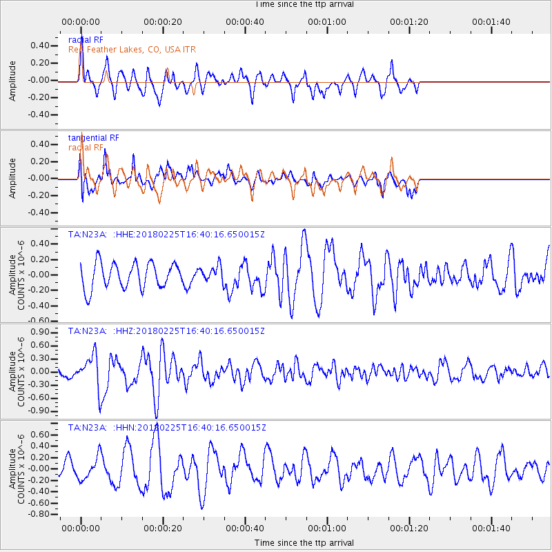
N23A Red Feather Lakes, CO, USA - Earthquake Result Viewer
*The percent match for this event was below the threshold and hence no stack was calculated.
| Earthquake location: |
Near East Coast Of Honshu, Japan |
| Earthquake latitude/longitude: |
37.6/141.7 |
| Earthquake time(UTC): |
2018/02/25 (056) 16:28:39 GMT |
| Earthquake Depth: |
31 km |
| Earthquake Magnitude: |
5.6 Mww |
| Earthquake Catalog/Contributor: |
NEIC PDE/us |
|
| Network: |
TA USArray Transportable Network (new EarthScope stations) |
| Station: |
N23A Red Feather Lakes, CO, USA |
| Lat/Lon: |
40.89 N/105.94 W |
| Elevation: |
2458 m |
|
| Distance: |
80.4 deg |
| Az: |
45.348 deg |
| Baz: |
311.803 deg |
| Ray Param: |
$rayparam |
*The percent match for this event was below the threshold and hence was not used in the summary stack. |
|
| Radial Match: |
69.31486 % |
| Radial Bump: |
400 |
| Transverse Match: |
77.708015 % |
| Transverse Bump: |
400 |
| SOD ConfigId: |
13570011 |
| Insert Time: |
2019-04-29 20:36:09.599 +0000 |
| GWidth: |
2.5 |
| Max Bumps: |
400 |
| Tol: |
0.001 |
|
Signal To Noise
| Channel | StoN | STA | LTA |
| TA:N23A: :HHZ:20180225T16:40:16.650015Z | 2.9795156 | 3.7966188E-7 | 1.2742403E-7 |
| TA:N23A: :HHN:20180225T16:40:16.650015Z | 1.599292 | 1.9892559E-7 | 1.2438353E-7 |
| TA:N23A: :HHE:20180225T16:40:16.650015Z | 0.6175531 | 1.00960634E-7 | 1.6348496E-7 |
| Arrivals |
| Ps | |
| PpPs | |
| PsPs/PpSs | |


