You are here: Home > Network List > TA - USArray Transportable Network (new EarthScope stations) Stations List
> Station 112A Yuma, AZ, USA > Earthquake Result Viewer
112A Yuma, AZ, USA - Earthquake Result Viewer

| Earthquake location: |
Tonga Islands |
| Earthquake latitude/longitude: |
-17.5/-174.3 |
| Earthquake time(UTC): |
2007/08/26 (238) 12:37:31 GMT |
| Earthquake Depth: |
127 km |
| Earthquake Magnitude: |
5.9 MB, 6.1 MW |
| Earthquake Catalog/Contributor: |
WHDF/NEIC |
|
| Network: |
TA USArray Transportable Network (new EarthScope stations) |
| Station: |
112A Yuma, AZ, USA |
| Lat/Lon: |
32.54 N/114.58 W |
| Elevation: |
87 m |
|
| Distance: |
75.7 deg |
| Az: |
48.846 deg |
| Baz: |
238.304 deg |
| Ray Param: |
0.051160816 |
| Estimated Moho Depth: |
60.25 km |
| Estimated Crust Vp/Vs: |
1.97 |
| Assumed Crust Vp: |
6.155 km/s |
| Estimated Crust Vs: |
3.132 km/s |
| Estimated Crust Poisson's Ratio: |
0.33 |
|
| Radial Match: |
83.63577 % |
| Radial Bump: |
367 |
| Transverse Match: |
75.856155 % |
| Transverse Bump: |
371 |
| SOD ConfigId: |
2564 |
| Insert Time: |
2010-03-06 09:16:53.014 +0000 |
| GWidth: |
2.5 |
| Max Bumps: |
400 |
| Tol: |
0.001 |
|
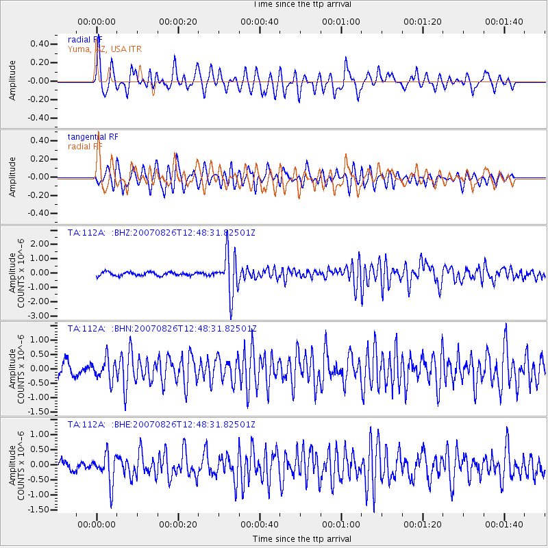
Signal To Noise
| Channel | StoN | STA | LTA |
| TA:112A: :BHN:20070826T12:48:31.82501Z | 2.1065197 | 3.7675042E-7 | 1.7884972E-7 |
| TA:112A: :BHE:20070826T12:48:31.82501Z | 3.538488 | 5.1119713E-7 | 1.4446768E-7 |
| TA:112A: :BHZ:20070826T12:48:31.82501Z | 11.950053 | 1.4727934E-6 | 1.2324577E-7 |
| Arrivals |
| Ps | 9.7 SECOND |
| PpPs | 28 SECOND |
| PsPs/PpSs | 38 SECOND |


