You are here: Home > Network List > TA - USArray Transportable Network (new EarthScope stations) Stations List
> Station 112A Yuma, AZ, USA > Earthquake Result Viewer
112A Yuma, AZ, USA - Earthquake Result Viewer
| Earthquake location: |
Jujuy Province, Argentina |
| Earthquake latitude/longitude: |
-22.2/-65.8 |
| Earthquake time(UTC): |
2007/07/21 (202) 15:34:52 GMT |
| Earthquake Depth: |
290 km |
| Earthquake Magnitude: |
5.8 MB, 6.4 MW, 6.3 MW |
| Earthquake Catalog/Contributor: |
WHDF/NEIC |
|
| Network: |
TA USArray Transportable Network (new EarthScope stations) |
| Station: |
112A Yuma, AZ, USA |
| Lat/Lon: |
32.54 N/114.58 W |
| Elevation: |
87 m |
|
| Distance: |
71.6 deg |
| Az: |
317.955 deg |
| Baz: |
132.69 deg |
| Ray Param: |
0.05335945 |
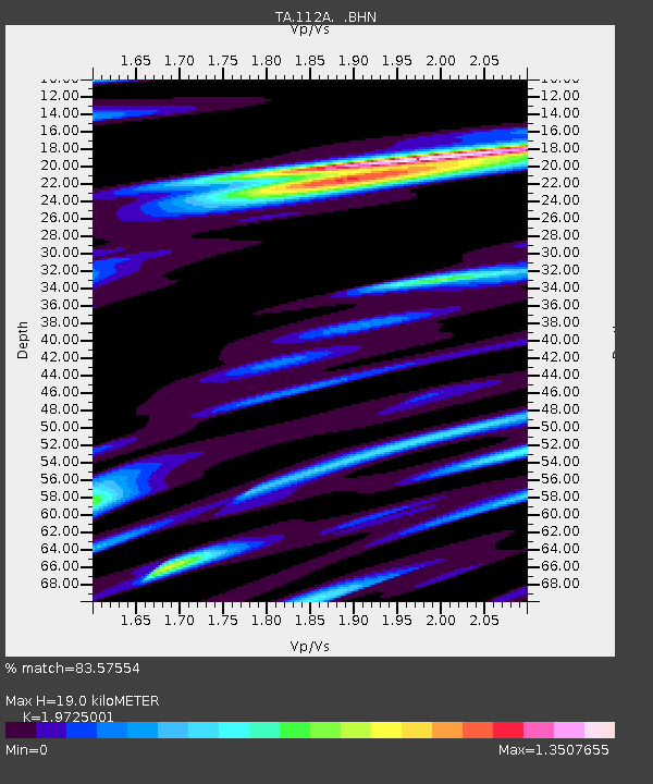
| Estimated Moho Depth: |
19.0 km |
| Estimated Crust Vp/Vs: |
1.97 |
| Assumed Crust Vp: |
6.155 km/s |
| Estimated Crust Vs: |
3.12 km/s |
| Estimated Crust Poisson's Ratio: |
0.33 |
|
| Radial Match: |
83.57554 % |
| Radial Bump: |
400 |
| Transverse Match: |
70.83793 % |
| Transverse Bump: |
400 |
| SOD ConfigId: |
2564 |
| Insert Time: |
2010-03-06 09:17:04.436 +0000 |
| GWidth: |
2.5 |
| Max Bumps: |
400 |
| Tol: |
0.001 |
|

Signal To Noise
| Channel | StoN | STA | LTA |
| TA:112A: :BHN:20070721T15:45:11.948022Z | 1.3652222 | 2.7734467E-7 | 2.0314984E-7 |
| TA:112A: :BHE:20070721T15:45:11.948022Z | 1.0977308 | 2.7673158E-7 | 2.520942E-7 |
| TA:112A: :BHZ:20070721T15:45:11.948022Z | 2.588293 | 4.0677176E-7 | 1.5715831E-7 |
| Arrivals |
| Ps | 3.1 SECOND |
| PpPs | 8.9 SECOND |
| PsPs/PpSs | 12 SECOND |


