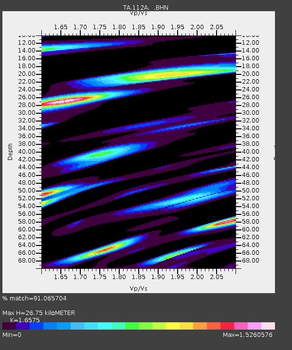
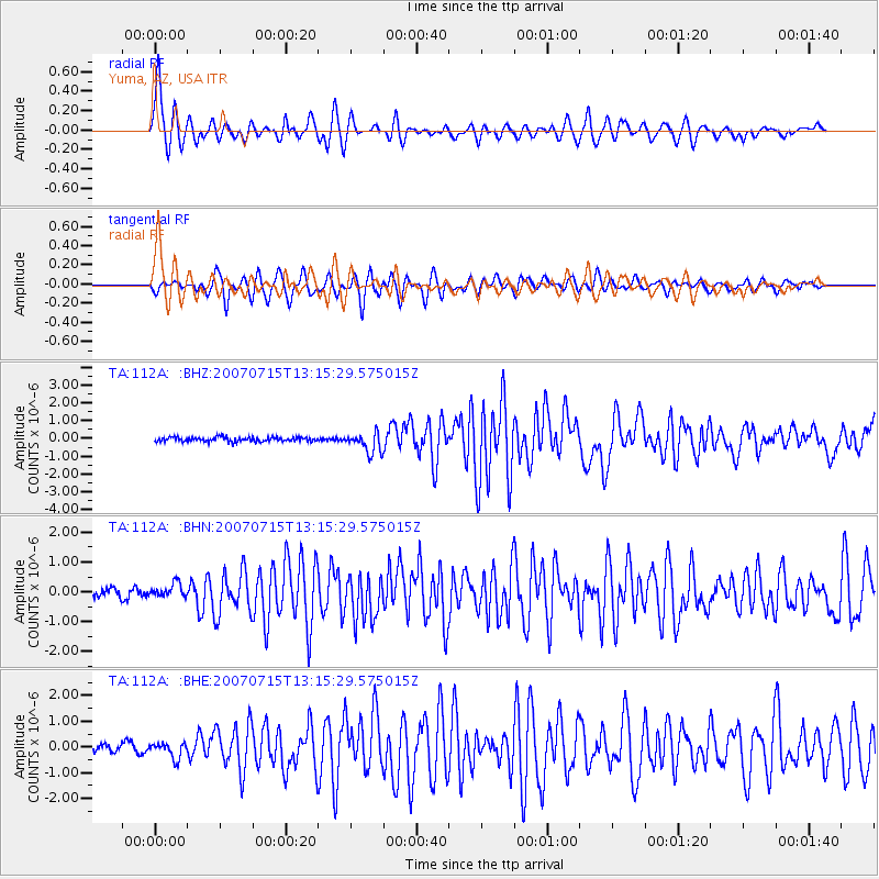
112A Yuma, AZ, USA - Earthquake Result Viewer

Earthquake location: Fox Islands, Aleutian Islands
Earthquake latitude/longitude: 52.5/-168.0
Earthquake time(UTC): 2007/07/15 (196) 13:08:00 GMT
Earthquake Depth: 10 km
Earthquake Magnitude: 5.8 MB, 5.9 MS, 6.1 MW, 6.0 MW
Earthquake Catalog/Contributor: WHDF/NEIC
Network: TA USArray Transportable Network (new EarthScope stations)
Station: 112A Yuma, AZ, USA
Lat/Lon: 32.54 N/114.58 W
Elevation: 87 m
Distance: 43.0 deg
Az: 95.925 deg
Baz: 313.928 deg
Ray Param: 0.07281461
Estimated Moho Depth: 26.75 km
Estimated Crust Vp/Vs: 1.66
Assumed Crust Vp: 6.155 km/s
Estimated Crust Vs: 3.713 km/s
Estimated Crust Poisson's Ratio: 0.21
Radial Match: 91.065704 %
Radial Bump: 400
Transverse Match: 81.246925 %
Transverse Bump: 400
SOD ConfigId: 2564
Insert Time: 2010-03-06 09:17:10.206 +0000
GWidth: 2.5
Max Bumps: 400
Tol: 0.001

Signal To Noise

ChannelStoNSTALTA
TA:112A: :BHN:20070715T13:15:29.575015Z1.61707222.3392184E-71.4465763E-7
TA:112A: :BHE:20070715T13:15:29.575015Z2.14909842.9257052E-71.3613639E-7
TA:112A: :BHZ:20070715T13:15:29.575015Z4.68021635.6465484E-71.2064716E-7
Arrivals
Ps3.1 SECOND
PpPs11 SECOND
PsPs/PpSs14 SECOND