You are here: Home > Network List > TA - USArray Transportable Network (new EarthScope stations) Stations List
> Station 112A Yuma, AZ, USA > Earthquake Result Viewer
112A Yuma, AZ, USA - Earthquake Result Viewer
| Earthquake location: |
Tonga Islands |
| Earthquake latitude/longitude: |
-20.1/-174.5 |
| Earthquake time(UTC): |
2007/05/27 (147) 18:12:34 GMT |
| Earthquake Depth: |
7.3 km |
| Earthquake Magnitude: |
5.8 MB, 5.1 MS, 5.6 MW, 5.5 MW |
| Earthquake Catalog/Contributor: |
WHDF/NEIC |
|
| Network: |
TA USArray Transportable Network (new EarthScope stations) |
| Station: |
112A Yuma, AZ, USA |
| Lat/Lon: |
32.54 N/114.58 W |
| Elevation: |
87 m |
|
| Distance: |
77.6 deg |
| Az: |
48.469 deg |
| Baz: |
236.417 deg |
| Ray Param: |
0.05023436 |
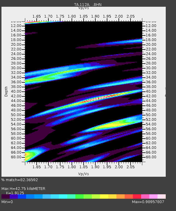
| Estimated Moho Depth: |
42.75 km |
| Estimated Crust Vp/Vs: |
1.91 |
| Assumed Crust Vp: |
6.155 km/s |
| Estimated Crust Vs: |
3.218 km/s |
| Estimated Crust Poisson's Ratio: |
0.31 |
|
| Radial Match: |
82.36592 % |
| Radial Bump: |
400 |
| Transverse Match: |
66.79079 % |
| Transverse Bump: |
400 |
| SOD ConfigId: |
2564 |
| Insert Time: |
2010-03-06 09:17:18.103 +0000 |
| GWidth: |
2.5 |
| Max Bumps: |
400 |
| Tol: |
0.001 |
|

Signal To Noise
| Channel | StoN | STA | LTA |
| TA:112A: :BHN:20070527T18:23:59.949016Z | 1.2354285 | 1.9756948E-7 | 1.5991981E-7 |
| TA:112A: :BHE:20070527T18:23:59.949016Z | 2.8345768 | 3.6190744E-7 | 1.27676E-7 |
| TA:112A: :BHZ:20070527T18:23:59.949016Z | 8.654569 | 8.90931E-7 | 1.0294343E-7 |
| Arrivals |
| Ps | 6.5 SECOND |
| PpPs | 20 SECOND |
| PsPs/PpSs | 26 SECOND |


