You are here: Home > Network List > CN - Canadian National Seismograph Network Stations List
> Station INK INUVIK, NT > Earthquake Result Viewer
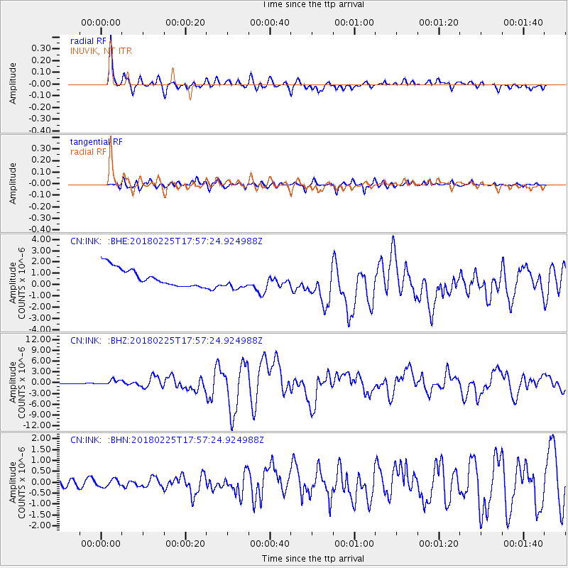
INK INUVIK, NT - Earthquake Result Viewer
*The percent match for this event was below the threshold and hence no stack was calculated.
| Earthquake location: |
New Guinea, Papua New Guinea |
| Earthquake latitude/longitude: |
-6.2/142.8 |
| Earthquake time(UTC): |
2018/02/25 (056) 17:44:39 GMT |
| Earthquake Depth: |
10 km |
| Earthquake Magnitude: |
7.6 Mi |
| Earthquake Catalog/Contributor: |
NEIC PDE/at |
|
| Network: |
CN Canadian National Seismograph Network |
| Station: |
INK INUVIK, NT |
| Lat/Lon: |
68.31 N/133.53 W |
| Elevation: |
44 m |
|
| Distance: |
93.4 deg |
| Az: |
21.726 deg |
| Baz: |
261.847 deg |
| Ray Param: |
$rayparam |
*The percent match for this event was below the threshold and hence was not used in the summary stack. |
|
| Radial Match: |
82.86898 % |
| Radial Bump: |
400 |
| Transverse Match: |
83.65968 % |
| Transverse Bump: |
400 |
| SOD ConfigId: |
13570011 |
| Insert Time: |
2019-04-29 20:40:03.920 +0000 |
| GWidth: |
2.5 |
| Max Bumps: |
400 |
| Tol: |
0.001 |
|
Signal To Noise
| Channel | StoN | STA | LTA |
| CN:INK: :BHZ:20180225T17:57:24.924988Z | 5.5379066 | 7.020968E-7 | 1.2678018E-7 |
| CN:INK: :BHN:20180225T17:57:24.924988Z | 0.93488526 | 1.6608519E-7 | 1.77653E-7 |
| CN:INK: :BHE:20180225T17:57:24.924988Z | 1.1675775 | 9.195337E-7 | 7.8755687E-7 |
| Arrivals |
| Ps | |
| PpPs | |
| PsPs/PpSs | |


