You are here: Home > Network List > TA - USArray Transportable Network (new EarthScope stations) Stations List
> Station F21K Alatna River, AK, USA > Earthquake Result Viewer
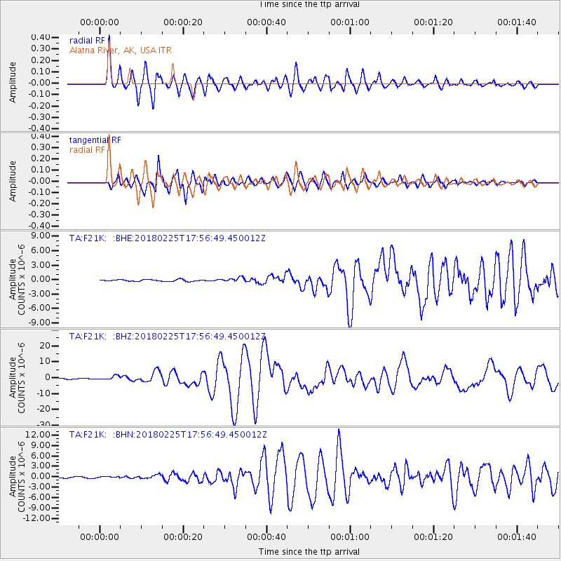
F21K Alatna River, AK, USA - Earthquake Result Viewer
*The percent match for this event was below the threshold and hence no stack was calculated.
| Earthquake location: |
New Guinea, Papua New Guinea |
| Earthquake latitude/longitude: |
-6.2/142.8 |
| Earthquake time(UTC): |
2018/02/25 (056) 17:44:39 GMT |
| Earthquake Depth: |
10 km |
| Earthquake Magnitude: |
7.6 Mi |
| Earthquake Catalog/Contributor: |
NEIC PDE/at |
|
| Network: |
TA USArray Transportable Network (new EarthScope stations) |
| Station: |
F21K Alatna River, AK, USA |
| Lat/Lon: |
67.22 N/153.48 W |
| Elevation: |
597 m |
|
| Distance: |
85.8 deg |
| Az: |
20.49 deg |
| Baz: |
243.355 deg |
| Ray Param: |
$rayparam |
*The percent match for this event was below the threshold and hence was not used in the summary stack. |
|
| Radial Match: |
89.21202 % |
| Radial Bump: |
400 |
| Transverse Match: |
91.74065 % |
| Transverse Bump: |
400 |
| SOD ConfigId: |
13570011 |
| Insert Time: |
2019-04-29 20:41:55.491 +0000 |
| GWidth: |
2.5 |
| Max Bumps: |
400 |
| Tol: |
0.001 |
|
Signal To Noise
| Channel | StoN | STA | LTA |
| TA:F21K: :BHZ:20180225T17:56:49.450012Z | 4.1467624 | 1.2082113E-6 | 2.9136254E-7 |
| TA:F21K: :BHN:20180225T17:56:49.450012Z | 0.8979376 | 1.9683294E-7 | 2.192056E-7 |
| TA:F21K: :BHE:20180225T17:56:49.450012Z | 0.9922336 | 1.8894985E-7 | 1.904288E-7 |
| Arrivals |
| Ps | |
| PpPs | |
| PsPs/PpSs | |


