You are here: Home > Network List > TA - USArray Transportable Network (new EarthScope stations) Stations List
> Station H16K Elim, AK, USA > Earthquake Result Viewer
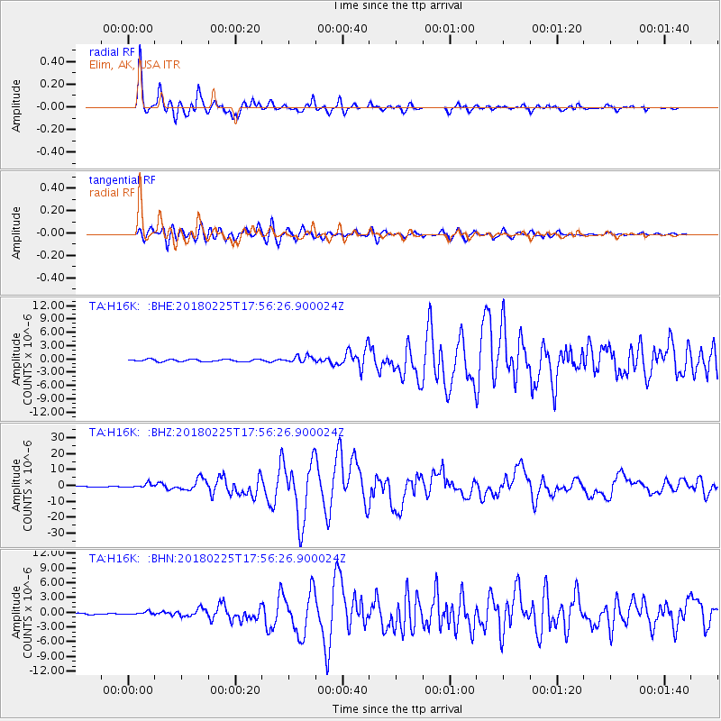
H16K Elim, AK, USA - Earthquake Result Viewer
*The percent match for this event was below the threshold and hence no stack was calculated.
| Earthquake location: |
New Guinea, Papua New Guinea |
| Earthquake latitude/longitude: |
-6.2/142.8 |
| Earthquake time(UTC): |
2018/02/25 (056) 17:44:39 GMT |
| Earthquake Depth: |
10 km |
| Earthquake Magnitude: |
7.6 Mi |
| Earthquake Catalog/Contributor: |
NEIC PDE/at |
|
| Network: |
TA USArray Transportable Network (new EarthScope stations) |
| Station: |
H16K Elim, AK, USA |
| Lat/Lon: |
64.64 N/162.24 W |
| Elevation: |
216 m |
|
| Distance: |
81.4 deg |
| Az: |
20.892 deg |
| Baz: |
235.409 deg |
| Ray Param: |
$rayparam |
*The percent match for this event was below the threshold and hence was not used in the summary stack. |
|
| Radial Match: |
97.0246 % |
| Radial Bump: |
400 |
| Transverse Match: |
90.15145 % |
| Transverse Bump: |
400 |
| SOD ConfigId: |
13570011 |
| Insert Time: |
2019-04-29 20:42:09.093 +0000 |
| GWidth: |
2.5 |
| Max Bumps: |
400 |
| Tol: |
0.001 |
|
Signal To Noise
| Channel | StoN | STA | LTA |
| TA:H16K: :BHZ:20180225T17:56:26.900024Z | 7.2208495 | 1.3274272E-6 | 1.8383255E-7 |
| TA:H16K: :BHN:20180225T17:56:26.900024Z | 2.2624114 | 2.95949E-7 | 1.3081132E-7 |
| TA:H16K: :BHE:20180225T17:56:26.900024Z | 2.0363255 | 5.2353556E-7 | 2.570982E-7 |
| Arrivals |
| Ps | |
| PpPs | |
| PsPs/PpSs | |


