You are here: Home > Network List > TA - USArray Transportable Network (new EarthScope stations) Stations List
> Station 109C Camp Elliot, Mirimar, CA, USA > Earthquake Result Viewer
109C Camp Elliot, Mirimar, CA, USA - Earthquake Result Viewer

| Earthquake location: |
Vanuatu Islands |
| Earthquake latitude/longitude: |
-14.8/168.0 |
| Earthquake time(UTC): |
2008/11/07 (312) 07:19:35 GMT |
| Earthquake Depth: |
13 km |
| Earthquake Magnitude: |
6.0 MB, 6.3 MS, 6.4 MW, 6.4 MW |
| Earthquake Catalog/Contributor: |
WHDF/NEIC |
|
| Network: |
TA USArray Transportable Network (new EarthScope stations) |
| Station: |
109C Camp Elliot, Mirimar, CA, USA |
| Lat/Lon: |
32.89 N/117.11 W |
| Elevation: |
150 m |
|
| Distance: |
85.7 deg |
| Az: |
54.536 deg |
| Baz: |
249.423 deg |
| Ray Param: |
0.04457348 |
| Estimated Moho Depth: |
24.0 km |
| Estimated Crust Vp/Vs: |
1.89 |
| Assumed Crust Vp: |
6.264 km/s |
| Estimated Crust Vs: |
3.31 km/s |
| Estimated Crust Poisson's Ratio: |
0.31 |
|
| Radial Match: |
91.386566 % |
| Radial Bump: |
257 |
| Transverse Match: |
82.896645 % |
| Transverse Bump: |
400 |
| SOD ConfigId: |
2658 |
| Insert Time: |
2010-03-06 09:18:49.976 +0000 |
| GWidth: |
2.5 |
| Max Bumps: |
400 |
| Tol: |
0.001 |
|
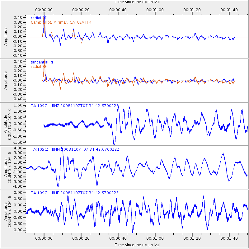
Signal To Noise
| Channel | StoN | STA | LTA |
| TA:109C: :BHN:20081107T07:31:42.670022Z | 3.0217412 | 6.2822306E-7 | 2.0790102E-7 |
| TA:109C: :BHE:20081107T07:31:42.670022Z | 0.9689922 | 1.16527595E-7 | 1.2025649E-7 |
| TA:109C: :BHZ:20081107T07:31:42.670022Z | 2.1647823 | 2.663964E-7 | 1.2305921E-7 |
| Arrivals |
| Ps | 3.5 SECOND |
| PpPs | 11 SECOND |
| PsPs/PpSs | 14 SECOND |


