You are here: Home > Network List > GS - US Geological Survey Networks Stations List
> Station DEC09 Decatur Surface Seismic Site, Decatur, IL, USA > Earthquake Result Viewer
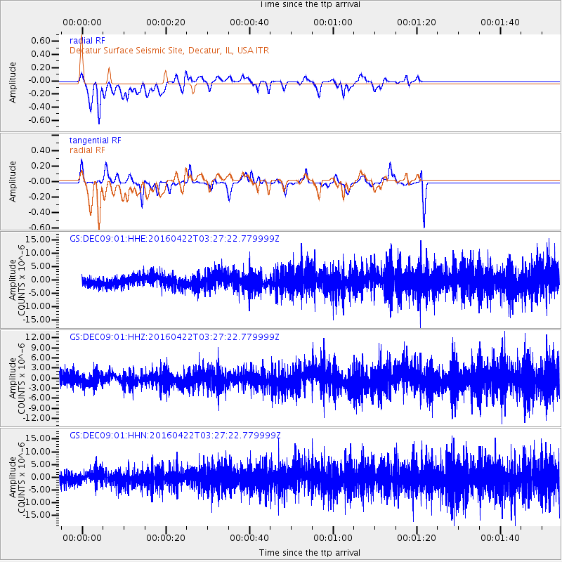
DEC09 Decatur Surface Seismic Site, Decatur, IL, USA - Earthquake Result Viewer
*The percent match for this event was below the threshold and hence no stack was calculated.
| Earthquake location: |
Near Coast Of Ecuador |
| Earthquake latitude/longitude: |
-0.3/-80.5 |
| Earthquake time(UTC): |
2016/04/22 (113) 03:20:13 GMT |
| Earthquake Depth: |
10 km |
| Earthquake Magnitude: |
5.8 MO |
| Earthquake Catalog/Contributor: |
NEIC PDE/NEIC ALERT |
|
| Network: |
GS US Geological Survey Networks |
| Station: |
DEC09 Decatur Surface Seismic Site, Decatur, IL, USA |
| Lat/Lon: |
39.87 N/88.92 W |
| Elevation: |
207 m |
|
| Distance: |
40.7 deg |
| Az: |
350.056 deg |
| Baz: |
167.032 deg |
| Ray Param: |
$rayparam |
*The percent match for this event was below the threshold and hence was not used in the summary stack. |
|
| Radial Match: |
66.884964 % |
| Radial Bump: |
400 |
| Transverse Match: |
48.32051 % |
| Transverse Bump: |
233 |
| SOD ConfigId: |
1475611 |
| Insert Time: |
2016-05-06 03:21:14.853 +0000 |
| GWidth: |
2.5 |
| Max Bumps: |
400 |
| Tol: |
0.001 |
|
Signal To Noise
| Channel | StoN | STA | LTA |
| GS:DEC09:01:HHZ:20160422T03:27:22.779999Z | 1.3748046 | 1.8836154E-6 | 1.3700967E-6 |
| GS:DEC09:01:HHN:20160422T03:27:22.779999Z | 1.2271906 | 2.6450948E-6 | 2.1554067E-6 |
| GS:DEC09:01:HHE:20160422T03:27:22.779999Z | 1.6605248 | 3.1977174E-6 | 1.925727E-6 |
| Arrivals |
| Ps | |
| PpPs | |
| PsPs/PpSs | |


