You are here: Home > Network List > TA - USArray Transportable Network (new EarthScope stations) Stations List
> Station C16K Lisburne Hills, AK, USA > Earthquake Result Viewer
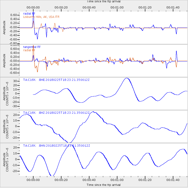
C16K Lisburne Hills, AK, USA - Earthquake Result Viewer
*The percent match for this event was below the threshold and hence no stack was calculated.
| Earthquake location: |
New Guinea, Papua New Guinea |
| Earthquake latitude/longitude: |
-5.8/142.2 |
| Earthquake time(UTC): |
2018/02/25 (056) 18:11:34 GMT |
| Earthquake Depth: |
39 km |
| Earthquake Magnitude: |
5.5 mb |
| Earthquake Catalog/Contributor: |
NEIC PDE/us |
|
| Network: |
TA USArray Transportable Network (new EarthScope stations) |
| Station: |
C16K Lisburne Hills, AK, USA |
| Lat/Lon: |
68.27 N/165.34 W |
| Elevation: |
102 m |
|
| Distance: |
82.3 deg |
| Az: |
17.319 deg |
| Baz: |
232.711 deg |
| Ray Param: |
$rayparam |
*The percent match for this event was below the threshold and hence was not used in the summary stack. |
|
| Radial Match: |
79.8599 % |
| Radial Bump: |
400 |
| Transverse Match: |
36.22729 % |
| Transverse Bump: |
264 |
| SOD ConfigId: |
13570011 |
| Insert Time: |
2019-04-29 20:45:57.942 +0000 |
| GWidth: |
2.5 |
| Max Bumps: |
400 |
| Tol: |
0.001 |
|
Signal To Noise
| Channel | StoN | STA | LTA |
| TA:C16K: :BHZ:20180225T18:23:21.350012Z | 0.67815 | 1.0060901E-5 | 1.4835805E-5 |
| TA:C16K: :BHN:20180225T18:23:21.350012Z | 0.5694996 | 1.02461545E-5 | 1.7991506E-5 |
| TA:C16K: :BHE:20180225T18:23:21.350012Z | 5.7673626 | 2.3712417E-5 | 4.1114836E-6 |
| Arrivals |
| Ps | |
| PpPs | |
| PsPs/PpSs | |


