You are here: Home > Network List > TA - USArray Transportable Network (new EarthScope stations) Stations List
> Station E17K Hotham Inlet, AK, USA > Earthquake Result Viewer
E17K Hotham Inlet, AK, USA - Earthquake Result Viewer
| Earthquake location: |
New Guinea, Papua New Guinea |
| Earthquake latitude/longitude: |
-5.8/142.2 |
| Earthquake time(UTC): |
2018/02/25 (056) 18:11:34 GMT |
| Earthquake Depth: |
39 km |
| Earthquake Magnitude: |
5.5 mb |
| Earthquake Catalog/Contributor: |
NEIC PDE/us |
|
| Network: |
TA USArray Transportable Network (new EarthScope stations) |
| Station: |
E17K Hotham Inlet, AK, USA |
| Lat/Lon: |
67.08 N/161.83 W |
| Elevation: |
233 m |
|
| Distance: |
82.7 deg |
| Az: |
19.089 deg |
| Baz: |
236.192 deg |
| Ray Param: |
0.04662751 |
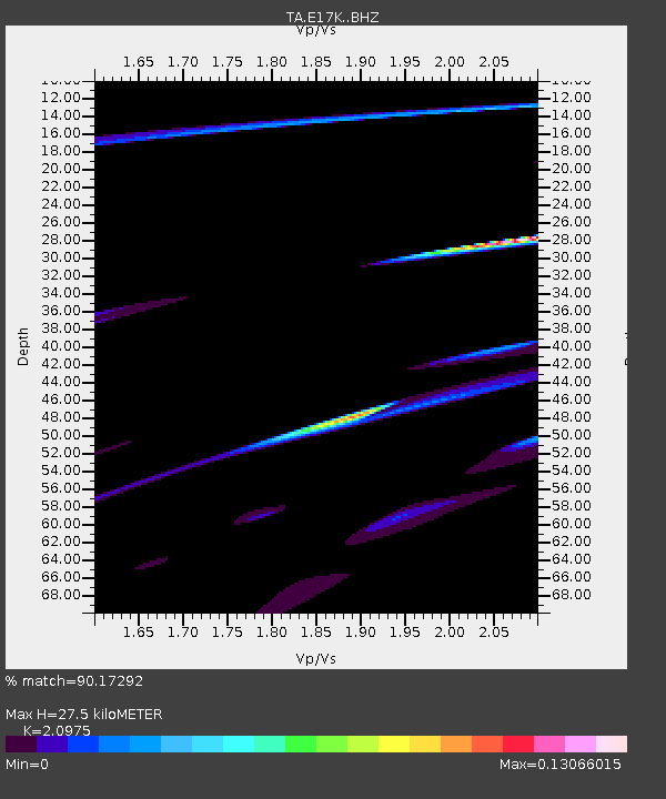
| Estimated Moho Depth: |
27.5 km |
| Estimated Crust Vp/Vs: |
2.10 |
| Assumed Crust Vp: |
6.276 km/s |
| Estimated Crust Vs: |
2.992 km/s |
| Estimated Crust Poisson's Ratio: |
0.35 |
|
| Radial Match: |
90.17292 % |
| Radial Bump: |
301 |
| Transverse Match: |
43.75971 % |
| Transverse Bump: |
222 |
| SOD ConfigId: |
13570011 |
| Insert Time: |
2019-04-29 20:46:00.856 +0000 |
| GWidth: |
2.5 |
| Max Bumps: |
400 |
| Tol: |
0.001 |
|

Signal To Noise
| Channel | StoN | STA | LTA |
| TA:E17K: :BHZ:20180225T18:23:23.400Z | 5.0598726 | 2.3838378E-5 | 4.7112608E-6 |
| TA:E17K: :BHN:20180225T18:23:23.400Z | 2.3300524 | 1.3648577E-5 | 5.8576265E-6 |
| TA:E17K: :BHE:20180225T18:23:23.400Z | 1.0749803 | 1.0244851E-5 | 9.5302685E-6 |
| Arrivals |
| Ps | 4.9 SECOND |
| PpPs | 13 SECOND |
| PsPs/PpSs | 18 SECOND |


