You are here: Home > Network List > TA - USArray Transportable Network (new EarthScope stations) Stations List
> Station E20K Nigu River, AK, USA > Earthquake Result Viewer
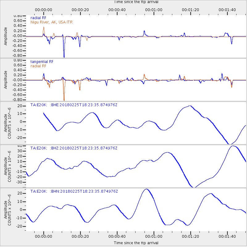
E20K Nigu River, AK, USA - Earthquake Result Viewer
*The percent match for this event was below the threshold and hence no stack was calculated.
| Earthquake location: |
New Guinea, Papua New Guinea |
| Earthquake latitude/longitude: |
-5.8/142.2 |
| Earthquake time(UTC): |
2018/02/25 (056) 18:11:34 GMT |
| Earthquake Depth: |
39 km |
| Earthquake Magnitude: |
5.5 mb |
| Earthquake Catalog/Contributor: |
NEIC PDE/us |
|
| Network: |
TA USArray Transportable Network (new EarthScope stations) |
| Station: |
E20K Nigu River, AK, USA |
| Lat/Lon: |
68.26 N/156.19 W |
| Elevation: |
866 m |
|
| Distance: |
85.2 deg |
| Az: |
19.196 deg |
| Baz: |
241.414 deg |
| Ray Param: |
$rayparam |
*The percent match for this event was below the threshold and hence was not used in the summary stack. |
|
| Radial Match: |
89.34681 % |
| Radial Bump: |
211 |
| Transverse Match: |
45.984665 % |
| Transverse Bump: |
400 |
| SOD ConfigId: |
13570011 |
| Insert Time: |
2019-04-29 20:46:01.461 +0000 |
| GWidth: |
2.5 |
| Max Bumps: |
400 |
| Tol: |
0.001 |
|
Signal To Noise
| Channel | StoN | STA | LTA |
| TA:E20K: :BHZ:20180225T18:23:35.874976Z | 2.5780137 | 1.7113518E-5 | 6.638257E-6 |
| TA:E20K: :BHN:20180225T18:23:35.874976Z | 0.47887227 | 3.4741443E-6 | 7.254845E-6 |
| TA:E20K: :BHE:20180225T18:23:35.874976Z | 0.94212544 | 5.329461E-6 | 5.6568488E-6 |
| Arrivals |
| Ps | |
| PpPs | |
| PsPs/PpSs | |


