You are here: Home > Network List > TA - USArray Transportable Network (new EarthScope stations) Stations List
> Station E18K Tukpahlearik Creek, AK, USA > Earthquake Result Viewer
E18K Tukpahlearik Creek, AK, USA - Earthquake Result Viewer
| Earthquake location: |
New Guinea, Papua New Guinea |
| Earthquake latitude/longitude: |
-5.8/142.2 |
| Earthquake time(UTC): |
2018/02/25 (056) 18:11:34 GMT |
| Earthquake Depth: |
39 km |
| Earthquake Magnitude: |
5.5 mb |
| Earthquake Catalog/Contributor: |
NEIC PDE/us |
|
| Network: |
TA USArray Transportable Network (new EarthScope stations) |
| Station: |
E18K Tukpahlearik Creek, AK, USA |
| Lat/Lon: |
67.42 N/160.60 W |
| Elevation: |
297 m |
|
| Distance: |
83.3 deg |
| Az: |
19.065 deg |
| Baz: |
237.316 deg |
| Ray Param: |
0.046218377 |
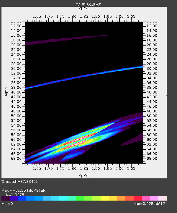
| Estimated Moho Depth: |
61.25 km |
| Estimated Crust Vp/Vs: |
1.83 |
| Assumed Crust Vp: |
6.276 km/s |
| Estimated Crust Vs: |
3.434 km/s |
| Estimated Crust Poisson's Ratio: |
0.29 |
|
| Radial Match: |
87.33451 % |
| Radial Bump: |
353 |
| Transverse Match: |
51.423622 % |
| Transverse Bump: |
261 |
| SOD ConfigId: |
13570011 |
| Insert Time: |
2019-04-29 20:46:01.503 +0000 |
| GWidth: |
2.5 |
| Max Bumps: |
400 |
| Tol: |
0.001 |
|

Signal To Noise
| Channel | StoN | STA | LTA |
| TA:E18K: :BHZ:20180225T18:23:26.425024Z | 0.64029837 | 6.7618394E-6 | 1.056045E-5 |
| TA:E18K: :BHN:20180225T18:23:26.425024Z | 0.33411723 | 2.6232478E-6 | 7.851279E-6 |
| TA:E18K: :BHE:20180225T18:23:26.425024Z | 4.6042676 | 1.918199E-5 | 4.166133E-6 |
| Arrivals |
| Ps | 8.3 SECOND |
| PpPs | 27 SECOND |
| PsPs/PpSs | 35 SECOND |


