You are here: Home > Network List > TA - USArray Transportable Network (new EarthScope stations) Stations List
> Station F17K Baldwin Penninsula, AK, USA > Earthquake Result Viewer
F17K Baldwin Penninsula, AK, USA - Earthquake Result Viewer
| Earthquake location: |
New Guinea, Papua New Guinea |
| Earthquake latitude/longitude: |
-5.8/142.2 |
| Earthquake time(UTC): |
2018/02/25 (056) 18:11:34 GMT |
| Earthquake Depth: |
39 km |
| Earthquake Magnitude: |
5.5 mb |
| Earthquake Catalog/Contributor: |
NEIC PDE/us |
|
| Network: |
TA USArray Transportable Network (new EarthScope stations) |
| Station: |
F17K Baldwin Penninsula, AK, USA |
| Lat/Lon: |
66.44 N/161.25 W |
| Elevation: |
51 m |
|
| Distance: |
82.6 deg |
| Az: |
19.757 deg |
| Baz: |
236.806 deg |
| Ray Param: |
0.04674157 |
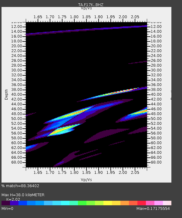
| Estimated Moho Depth: |
38.0 km |
| Estimated Crust Vp/Vs: |
2.02 |
| Assumed Crust Vp: |
6.276 km/s |
| Estimated Crust Vs: |
3.107 km/s |
| Estimated Crust Poisson's Ratio: |
0.34 |
|
| Radial Match: |
88.36402 % |
| Radial Bump: |
390 |
| Transverse Match: |
60.945866 % |
| Transverse Bump: |
388 |
| SOD ConfigId: |
13570011 |
| Insert Time: |
2019-04-29 20:46:04.367 +0000 |
| GWidth: |
2.5 |
| Max Bumps: |
400 |
| Tol: |
0.001 |
|

Signal To Noise
| Channel | StoN | STA | LTA |
| TA:F17K: :BHZ:20180225T18:23:22.550024Z | 2.4897392 | 3.7418864E-5 | 1.5029232E-5 |
| TA:F17K: :BHN:20180225T18:23:22.550024Z | 0.2515999 | 2.1044734E-6 | 8.3643645E-6 |
| TA:F17K: :BHE:20180225T18:23:22.550024Z | 0.94242865 | 1.5966736E-5 | 1.6942116E-5 |
| Arrivals |
| Ps | 6.3 SECOND |
| PpPs | 18 SECOND |
| PsPs/PpSs | 24 SECOND |


