You are here: Home > Network List > TA - USArray Transportable Network (new EarthScope stations) Stations List
> Station M19K Big River Lodge, Big River, AK, USA > Earthquake Result Viewer
M19K Big River Lodge, Big River, AK, USA - Earthquake Result Viewer
| Earthquake location: |
New Guinea, Papua New Guinea |
| Earthquake latitude/longitude: |
-5.8/142.2 |
| Earthquake time(UTC): |
2018/02/25 (056) 18:11:34 GMT |
| Earthquake Depth: |
39 km |
| Earthquake Magnitude: |
5.5 mb |
| Earthquake Catalog/Contributor: |
NEIC PDE/us |
|
| Network: |
TA USArray Transportable Network (new EarthScope stations) |
| Station: |
M19K Big River Lodge, Big River, AK, USA |
| Lat/Lon: |
61.90 N/154.39 W |
| Elevation: |
521 m |
|
| Distance: |
82.9 deg |
| Az: |
25.242 deg |
| Baz: |
243.672 deg |
| Ray Param: |
0.046499014 |
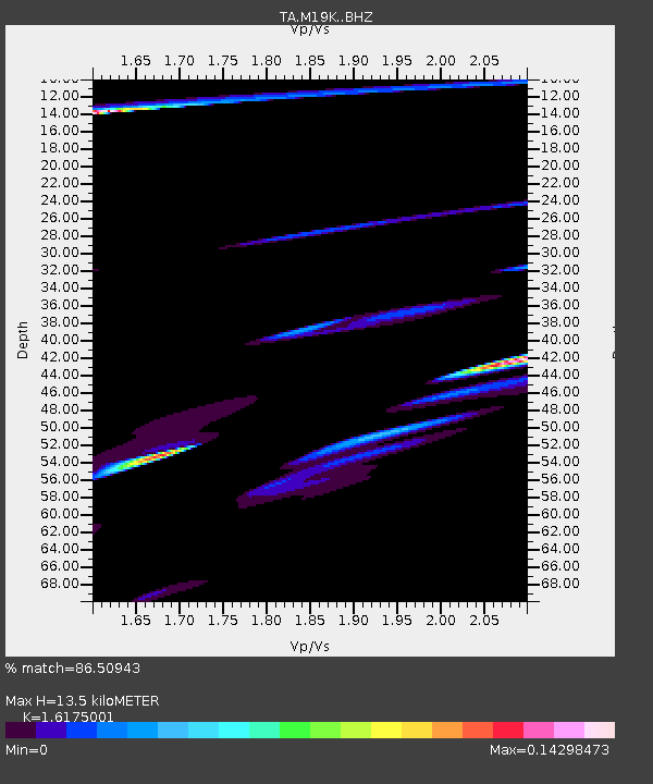
| Estimated Moho Depth: |
13.5 km |
| Estimated Crust Vp/Vs: |
1.62 |
| Assumed Crust Vp: |
6.566 km/s |
| Estimated Crust Vs: |
4.059 km/s |
| Estimated Crust Poisson's Ratio: |
0.19 |
|
| Radial Match: |
86.50943 % |
| Radial Bump: |
375 |
| Transverse Match: |
34.909348 % |
| Transverse Bump: |
244 |
| SOD ConfigId: |
13570011 |
| Insert Time: |
2019-04-29 20:46:28.856 +0000 |
| GWidth: |
2.5 |
| Max Bumps: |
400 |
| Tol: |
0.001 |
|

Signal To Noise
| Channel | StoN | STA | LTA |
| TA:M19K: :BHZ:20180225T18:23:24.324988Z | 3.074973 | 2.3524051E-5 | 7.650165E-6 |
| TA:M19K: :BHN:20180225T18:23:24.324988Z | 0.94203603 | 1.6532806E-5 | 1.7550077E-5 |
| TA:M19K: :BHE:20180225T18:23:24.324988Z | 1.979392 | 1.51276245E-5 | 7.642561E-6 |
| Arrivals |
| Ps | 1.3 SECOND |
| PpPs | 5.2 SECOND |
| PsPs/PpSs | 6.5 SECOND |


