You are here: Home > Network List > TA - USArray Transportable Network (new EarthScope stations) Stations List
> Station M31M Drury Creek, Yukon, CA > Earthquake Result Viewer
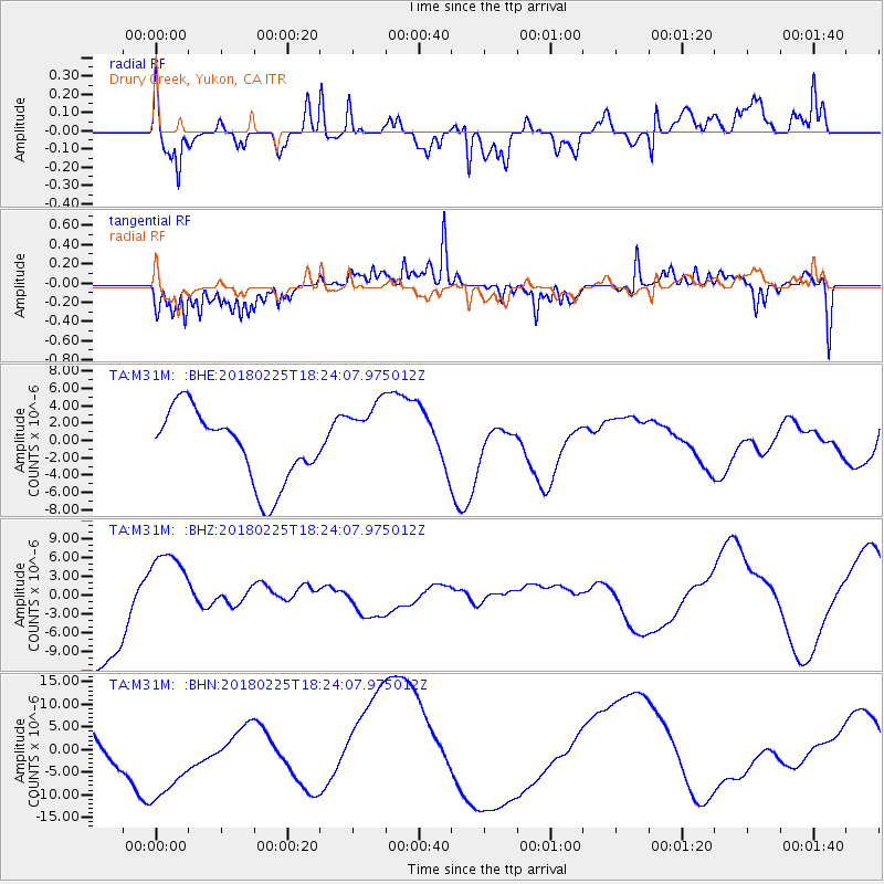
M31M Drury Creek, Yukon, CA - Earthquake Result Viewer
*The percent match for this event was below the threshold and hence no stack was calculated.
| Earthquake location: |
New Guinea, Papua New Guinea |
| Earthquake latitude/longitude: |
-5.8/142.2 |
| Earthquake time(UTC): |
2018/02/25 (056) 18:11:34 GMT |
| Earthquake Depth: |
39 km |
| Earthquake Magnitude: |
5.5 mb |
| Earthquake Catalog/Contributor: |
NEIC PDE/us |
|
| Network: |
TA USArray Transportable Network (new EarthScope stations) |
| Station: |
M31M Drury Creek, Yukon, CA |
| Lat/Lon: |
62.20 N/134.39 W |
| Elevation: |
639 m |
|
| Distance: |
92.0 deg |
| Az: |
27.771 deg |
| Baz: |
261.467 deg |
| Ray Param: |
$rayparam |
*The percent match for this event was below the threshold and hence was not used in the summary stack. |
|
| Radial Match: |
60.685524 % |
| Radial Bump: |
400 |
| Transverse Match: |
61.787514 % |
| Transverse Bump: |
318 |
| SOD ConfigId: |
13570011 |
| Insert Time: |
2019-04-29 20:46:32.130 +0000 |
| GWidth: |
2.5 |
| Max Bumps: |
400 |
| Tol: |
0.001 |
|
Signal To Noise
| Channel | StoN | STA | LTA |
| TA:M31M: :BHZ:20180225T18:24:07.975012Z | 0.7884814 | 6.6025978E-6 | 8.373815E-6 |
| TA:M31M: :BHN:20180225T18:24:07.975012Z | 2.1044374 | 1.1550211E-5 | 5.488503E-6 |
| TA:M31M: :BHE:20180225T18:24:07.975012Z | 1.0382982 | 4.293229E-6 | 4.1348703E-6 |
| Arrivals |
| Ps | |
| PpPs | |
| PsPs/PpSs | |


