You are here: Home > Network List > TA - USArray Transportable Network (new EarthScope stations) Stations List
> Station P19K Oil Pt, AK, USA > Earthquake Result Viewer
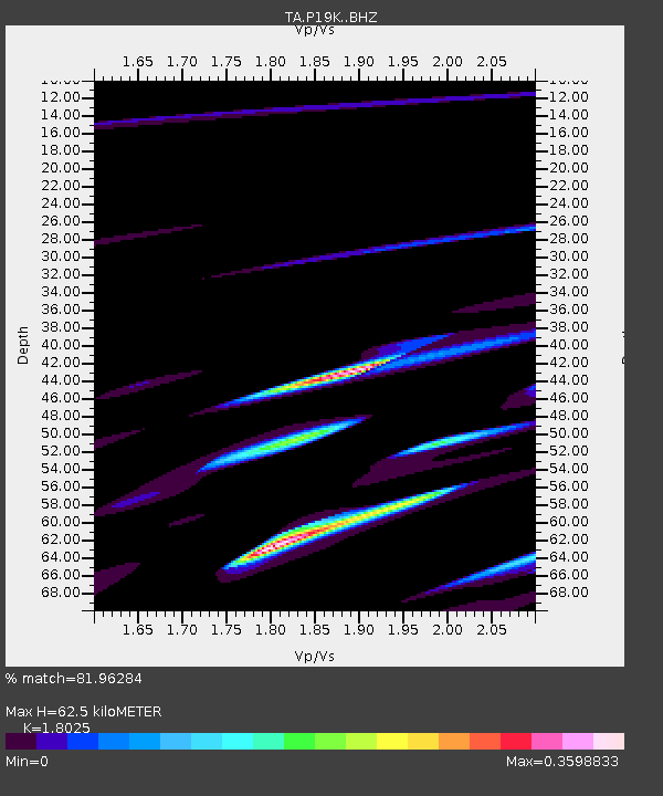
P19K Oil Pt, AK, USA - Earthquake Result Viewer
| Earthquake location: |
New Guinea, Papua New Guinea |
| Earthquake latitude/longitude: |
-5.8/142.2 |
| Earthquake time(UTC): |
2018/02/25 (056) 18:11:34 GMT |
| Earthquake Depth: |
39 km |
| Earthquake Magnitude: |
5.5 mb |
| Earthquake Catalog/Contributor: |
NEIC PDE/us |
|
| Network: |
TA USArray Transportable Network (new EarthScope stations) |
| Station: |
P19K Oil Pt, AK, USA |
| Lat/Lon: |
59.65 N/153.23 W |
| Elevation: |
629 m |
|
| Distance: |
82.4 deg |
| Az: |
27.543 deg |
| Baz: |
244.975 deg |
| Ray Param: |
0.046822555 |
| Estimated Moho Depth: |
62.5 km |
| Estimated Crust Vp/Vs: |
1.80 |
| Assumed Crust Vp: |
5.989 km/s |
| Estimated Crust Vs: |
3.323 km/s |
| Estimated Crust Poisson's Ratio: |
0.28 |
|
| Radial Match: |
81.96284 % |
| Radial Bump: |
400 |
| Transverse Match: |
45.52413 % |
| Transverse Bump: |
377 |
| SOD ConfigId: |
13570011 |
| Insert Time: |
2019-04-29 20:46:39.004 +0000 |
| GWidth: |
2.5 |
| Max Bumps: |
400 |
| Tol: |
0.001 |
|

Signal To Noise
| Channel | StoN | STA | LTA |
| TA:P19K: :BHZ:20180225T18:23:21.900Z | 1.9013686 | 2.4535537E-5 | 1.2904145E-5 |
| TA:P19K: :BHN:20180225T18:23:21.900Z | 0.7982839 | 1.4083356E-5 | 1.764204E-5 |
| TA:P19K: :BHE:20180225T18:23:21.900Z | 0.6142459 | 1.0934304E-5 | 1.7801183E-5 |
| Arrivals |
| Ps | 8.6 SECOND |
| PpPs | 29 SECOND |
| PsPs/PpSs | 37 SECOND |


