You are here: Home > Network List > AV - Alaska Volcano Observatory Stations List
> Station MAPS Pakushin Southeast, Makushin Volcano, Alaska > Earthquake Result Viewer
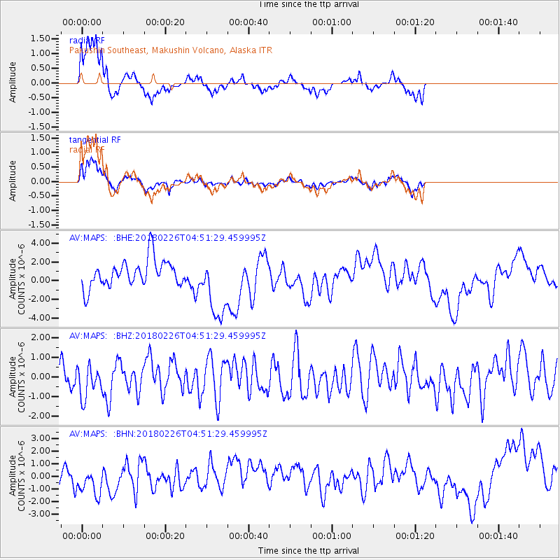
MAPS Pakushin Southeast, Makushin Volcano, Alaska - Earthquake Result Viewer
*The percent match for this event was below the threshold and hence no stack was calculated.
| Earthquake location: |
New Britain Region, P.N.G. |
| Earthquake latitude/longitude: |
-5.4/151.8 |
| Earthquake time(UTC): |
2018/02/26 (057) 04:41:02 GMT |
| Earthquake Depth: |
35 km |
| Earthquake Magnitude: |
5.6 Mww |
| Earthquake Catalog/Contributor: |
NEIC PDE/us |
|
| Network: |
AV Alaska Volcano Observatory |
| Station: |
MAPS Pakushin Southeast, Makushin Volcano, Alaska |
| Lat/Lon: |
53.81 N/166.94 W |
| Elevation: |
333 m |
|
| Distance: |
68.4 deg |
| Az: |
24.864 deg |
| Baz: |
224.897 deg |
| Ray Param: |
$rayparam |
*The percent match for this event was below the threshold and hence was not used in the summary stack. |
|
| Radial Match: |
77.511986 % |
| Radial Bump: |
400 |
| Transverse Match: |
64.49577 % |
| Transverse Bump: |
400 |
| SOD ConfigId: |
13570011 |
| Insert Time: |
2019-04-29 20:47:53.313 +0000 |
| GWidth: |
2.5 |
| Max Bumps: |
400 |
| Tol: |
0.001 |
|
Signal To Noise
| Channel | StoN | STA | LTA |
| AV:MAPS: :BHZ:20180226T04:51:29.459995Z | 0.59884995 | 8.200488E-7 | 1.3693726E-6 |
| AV:MAPS: :BHN:20180226T04:51:29.459995Z | 1.2799994 | 1.2639437E-6 | 9.874564E-7 |
| AV:MAPS: :BHE:20180226T04:51:29.459995Z | 2.469067 | 3.5455867E-6 | 1.4360027E-6 |
| Arrivals |
| Ps | |
| PpPs | |
| PsPs/PpSs | |


