You are here: Home > Network List > TA - USArray Transportable Network (new EarthScope stations) Stations List
> Station 109C Camp Elliot, Mirimar, CA, USA > Earthquake Result Viewer
109C Camp Elliot, Mirimar, CA, USA - Earthquake Result Viewer
| Earthquake location: |
Mariana Islands |
| Earthquake latitude/longitude: |
18.9/145.4 |
| Earthquake time(UTC): |
2007/10/31 (304) 03:30:17 GMT |
| Earthquake Depth: |
223 km |
| Earthquake Magnitude: |
6.2 MB, 7.2 MW, 7.2 MW |
| Earthquake Catalog/Contributor: |
WHDF/NEIC |
|
| Network: |
TA USArray Transportable Network (new EarthScope stations) |
| Station: |
109C Camp Elliot, Mirimar, CA, USA |
| Lat/Lon: |
32.89 N/117.11 W |
| Elevation: |
150 m |
|
| Distance: |
86.0 deg |
| Az: |
56.736 deg |
| Baz: |
289.8 deg |
| Ray Param: |
0.043824382 |
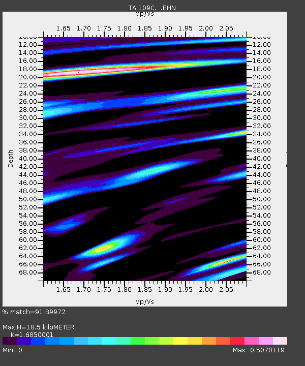
| Estimated Moho Depth: |
18.5 km |
| Estimated Crust Vp/Vs: |
1.69 |
| Assumed Crust Vp: |
6.264 km/s |
| Estimated Crust Vs: |
3.717 km/s |
| Estimated Crust Poisson's Ratio: |
0.23 |
|
| Radial Match: |
91.89972 % |
| Radial Bump: |
369 |
| Transverse Match: |
78.31567 % |
| Transverse Bump: |
400 |
| SOD ConfigId: |
2564 |
| Insert Time: |
2010-03-06 09:19:49.007 +0000 |
| GWidth: |
2.5 |
| Max Bumps: |
400 |
| Tol: |
0.001 |
|

Signal To Noise
| Channel | StoN | STA | LTA |
| TA:109C: :BHN:20071031T03:42:01.519009Z | 3.06324 | 6.9830713E-7 | 2.2796358E-7 |
| TA:109C: :BHE:20071031T03:42:01.519009Z | 4.7572436 | 1.3281947E-6 | 2.7919418E-7 |
| TA:109C: :BHZ:20071031T03:42:01.519009Z | 10.60327 | 4.021274E-6 | 3.792485E-7 |
| Arrivals |
| Ps | 2.1 SECOND |
| PpPs | 7.8 SECOND |
| PsPs/PpSs | 9.8 SECOND |


