You are here: Home > Network List > TA - USArray Transportable Network (new EarthScope stations) Stations List
> Station 109C Camp Elliot, Mirimar, CA, USA > Earthquake Result Viewer
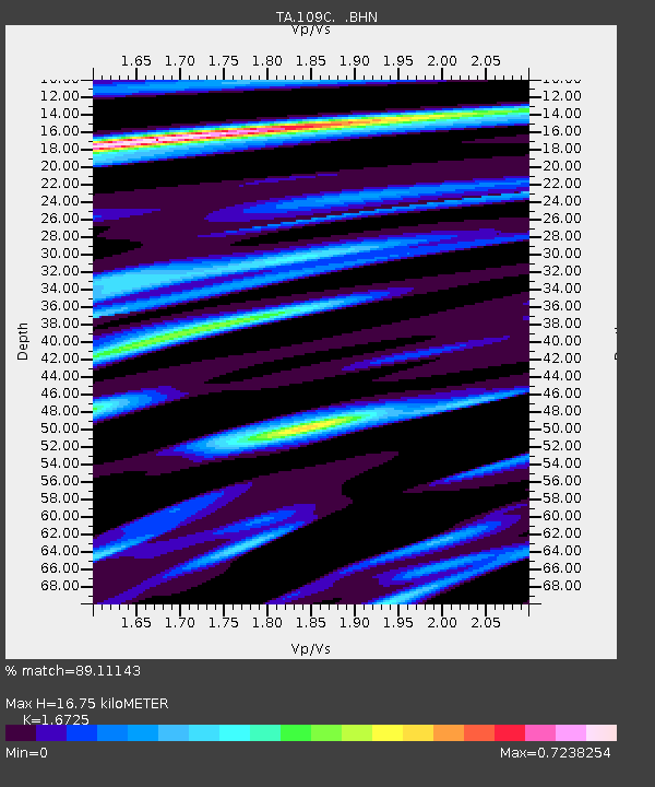
109C Camp Elliot, Mirimar, CA, USA - Earthquake Result Viewer
| Earthquake location: |
Vanuatu Islands |
| Earthquake latitude/longitude: |
-17.8/167.9 |
| Earthquake time(UTC): |
2009/06/02 (153) 02:17:03 GMT |
| Earthquake Depth: |
15 km |
| Earthquake Magnitude: |
5.7 MB, 6.2 MS, 6.3 MW, 6.3 MW |
| Earthquake Catalog/Contributor: |
WHDF/NEIC |
|
| Network: |
TA USArray Transportable Network (new EarthScope stations) |
| Station: |
109C Camp Elliot, Mirimar, CA, USA |
| Lat/Lon: |
32.89 N/117.11 W |
| Elevation: |
150 m |
|
| Distance: |
87.5 deg |
| Az: |
54.421 deg |
| Baz: |
247.096 deg |
| Ray Param: |
0.043306336 |
| Estimated Moho Depth: |
16.75 km |
| Estimated Crust Vp/Vs: |
1.67 |
| Assumed Crust Vp: |
6.264 km/s |
| Estimated Crust Vs: |
3.745 km/s |
| Estimated Crust Poisson's Ratio: |
0.22 |
|
| Radial Match: |
89.11143 % |
| Radial Bump: |
336 |
| Transverse Match: |
74.421394 % |
| Transverse Bump: |
400 |
| SOD ConfigId: |
2648 |
| Insert Time: |
2010-03-06 09:20:26.898 +0000 |
| GWidth: |
2.5 |
| Max Bumps: |
400 |
| Tol: |
0.001 |
|

Signal To Noise
| Channel | StoN | STA | LTA |
| TA:109C: :BHN:20090602T02:29:18.720022Z | 4.6327505 | 5.951525E-7 | 1.2846634E-7 |
| TA:109C: :BHE:20090602T02:29:18.720022Z | 0.717696 | 8.375992E-8 | 1.1670669E-7 |
| TA:109C: :BHZ:20090602T02:29:18.720022Z | 1.7796055 | 2.0723023E-7 | 1.1644728E-7 |
| Arrivals |
| Ps | 1.8 SECOND |
| PpPs | 7.0 SECOND |
| PsPs/PpSs | 8.8 SECOND |


