You are here: Home > Network List > PS - Pacific21 Stations List
> Station PSI Parapat, Indonesia > Earthquake Result Viewer
PSI Parapat, Indonesia - Earthquake Result Viewer
| Earthquake location: |
New Guinea, Papua New Guinea |
| Earthquake latitude/longitude: |
-6.4/143.3 |
| Earthquake time(UTC): |
2018/02/26 (057) 08:26:59 GMT |
| Earthquake Depth: |
24 km |
| Earthquake Magnitude: |
6.0 Mww |
| Earthquake Catalog/Contributor: |
NEIC PDE/us |
|
| Network: |
PS Pacific21 |
| Station: |
PSI Parapat, Indonesia |
| Lat/Lon: |
2.69 N/98.92 E |
| Elevation: |
987 m |
|
| Distance: |
45.2 deg |
| Az: |
280.216 deg |
| Baz: |
101.732 deg |
| Ray Param: |
0.07140119 |
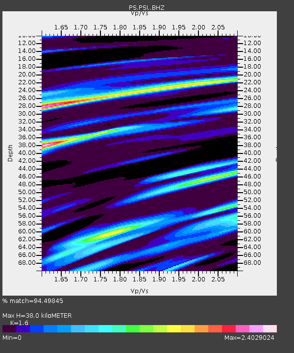
| Estimated Moho Depth: |
38.0 km |
| Estimated Crust Vp/Vs: |
1.60 |
| Assumed Crust Vp: |
6.468 km/s |
| Estimated Crust Vs: |
4.042 km/s |
| Estimated Crust Poisson's Ratio: |
0.18 |
|
| Radial Match: |
94.49845 % |
| Radial Bump: |
400 |
| Transverse Match: |
70.23695 % |
| Transverse Bump: |
400 |
| SOD ConfigId: |
13570011 |
| Insert Time: |
2019-04-29 20:54:34.014 +0000 |
| GWidth: |
2.5 |
| Max Bumps: |
400 |
| Tol: |
0.001 |
|
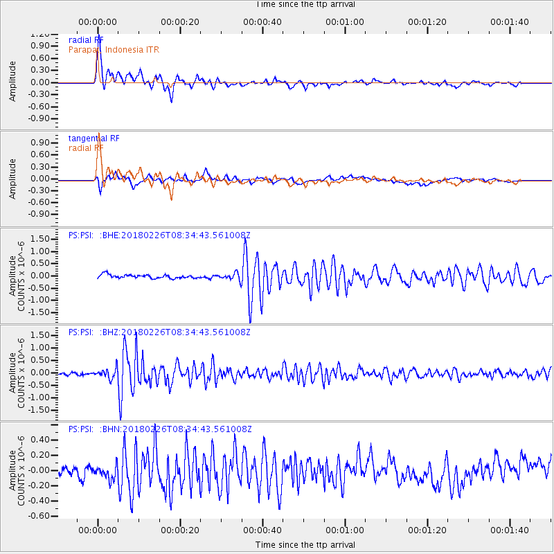
Signal To Noise
| Channel | StoN | STA | LTA |
| PS:PSI: :BHZ:20180226T08:34:43.561008Z | 5.0577984 | 1.9860377E-7 | 3.9266844E-8 |
| PS:PSI: :BHN:20180226T08:34:43.561008Z | 1.0091008 | 1.0221228E-7 | 1.0129045E-7 |
| PS:PSI: :BHE:20180226T08:34:43.561008Z | 1.9844913 | 1.4487641E-7 | 7.300431E-8 |
| Arrivals |
| Ps | 3.8 SECOND |
| PpPs | 14 SECOND |
| PsPs/PpSs | 18 SECOND |


