You are here: Home > Network List > TA - USArray Transportable Network (new EarthScope stations) Stations List
> Station 109C Camp Elliot, Mirimar, CA, USA > Earthquake Result Viewer
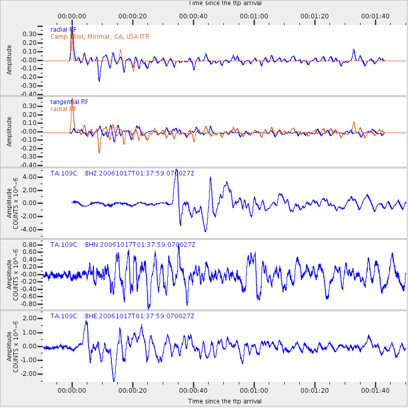
109C Camp Elliot, Mirimar, CA, USA - Earthquake Result Viewer
| Earthquake location: |
New Britain Region, P.N.G. |
| Earthquake latitude/longitude: |
-5.9/151.0 |
| Earthquake time(UTC): |
2006/10/17 (290) 01:25:12 GMT |
| Earthquake Depth: |
32 km |
| Earthquake Magnitude: |
6.4 MB, 6.9 MS, 6.7 MW, 6.6 MW |
| Earthquake Catalog/Contributor: |
WHDF/NEIC |
|
| Network: |
TA USArray Transportable Network (new EarthScope stations) |
| Station: |
109C Camp Elliot, Mirimar, CA, USA |
| Lat/Lon: |
32.89 N/117.11 W |
| Elevation: |
150 m |
|
| Distance: |
94.8 deg |
| Az: |
57.546 deg |
| Baz: |
266.105 deg |
| Ray Param: |
0.04094907 |
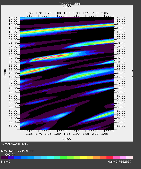
| Estimated Moho Depth: |
31.5 km |
| Estimated Crust Vp/Vs: |
1.74 |
| Assumed Crust Vp: |
6.264 km/s |
| Estimated Crust Vs: |
3.6 km/s |
| Estimated Crust Poisson's Ratio: |
0.25 |
|
| Radial Match: |
90.8217 % |
| Radial Bump: |
385 |
| Transverse Match: |
79.88443 % |
| Transverse Bump: |
400 |
| SOD ConfigId: |
2665 |
| Insert Time: |
2010-03-06 09:20:58.318 +0000 |
| GWidth: |
2.5 |
| Max Bumps: |
400 |
| Tol: |
0.001 |
|
Signal To Noise
| Channel | StoN | STA | LTA |
| TA:109C: :BHN:20061017T01:37:59.070027Z | 0.80840915 | 6.9029596E-8 | 8.538943E-8 |
| TA:109C: :BHE:20061017T01:37:59.070027Z | 7.4356794 | 6.9840144E-7 | 9.3925706E-8 |
| TA:109C: :BHZ:20061017T01:37:59.070027Z | 10.875235 | 2.152303E-6 | 1.9790866E-7 |
| Arrivals |
| Ps | 3.8 SECOND |
| PpPs | 14 SECOND |
| PsPs/PpSs | 17 SECOND |


