You are here: Home > Network List > TA - USArray Transportable Network (new EarthScope stations) Stations List
> Station R33M Jennings River, BC, CAN > Earthquake Result Viewer
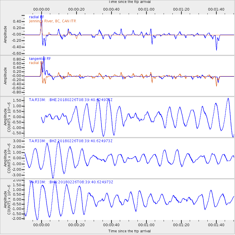
R33M Jennings River, BC, CAN - Earthquake Result Viewer
*The percent match for this event was below the threshold and hence no stack was calculated.
| Earthquake location: |
New Guinea, Papua New Guinea |
| Earthquake latitude/longitude: |
-6.4/143.3 |
| Earthquake time(UTC): |
2018/02/26 (057) 08:26:59 GMT |
| Earthquake Depth: |
24 km |
| Earthquake Magnitude: |
6.0 Mww |
| Earthquake Catalog/Contributor: |
NEIC PDE/us |
|
| Network: |
TA USArray Transportable Network (new EarthScope stations) |
| Station: |
R33M Jennings River, BC, CAN |
| Lat/Lon: |
59.39 N/130.97 W |
| Elevation: |
1437 m |
|
| Distance: |
93.3 deg |
| Az: |
30.738 deg |
| Baz: |
263.096 deg |
| Ray Param: |
$rayparam |
*The percent match for this event was below the threshold and hence was not used in the summary stack. |
|
| Radial Match: |
79.68446 % |
| Radial Bump: |
400 |
| Transverse Match: |
86.89087 % |
| Transverse Bump: |
383 |
| SOD ConfigId: |
13570011 |
| Insert Time: |
2019-04-29 20:55:14.994 +0000 |
| GWidth: |
2.5 |
| Max Bumps: |
400 |
| Tol: |
0.001 |
|
Signal To Noise
| Channel | StoN | STA | LTA |
| TA:R33M: :BHZ:20180226T08:39:40.624973Z | 3.069338 | 1.6995303E-6 | 5.5371237E-7 |
| TA:R33M: :BHN:20180226T08:39:40.624973Z | 1.4343208 | 1.1927829E-6 | 8.316012E-7 |
| TA:R33M: :BHE:20180226T08:39:40.624973Z | 2.4974432 | 1.0973403E-6 | 4.3938547E-7 |
| Arrivals |
| Ps | |
| PpPs | |
| PsPs/PpSs | |


