You are here: Home > Network List > PS - Pacific21 Stations List
> Station PSI Parapat, Indonesia > Earthquake Result Viewer
PSI Parapat, Indonesia - Earthquake Result Viewer
| Earthquake location: |
New Guinea, Papua New Guinea |
| Earthquake latitude/longitude: |
-6.5/143.6 |
| Earthquake time(UTC): |
2018/02/26 (057) 11:56:07 GMT |
| Earthquake Depth: |
13 km |
| Earthquake Magnitude: |
5.7 Mww |
| Earthquake Catalog/Contributor: |
NEIC PDE/us |
|
| Network: |
PS Pacific21 |
| Station: |
PSI Parapat, Indonesia |
| Lat/Lon: |
2.69 N/98.92 E |
| Elevation: |
987 m |
|
| Distance: |
45.5 deg |
| Az: |
280.205 deg |
| Baz: |
101.762 deg |
| Ray Param: |
0.071239434 |
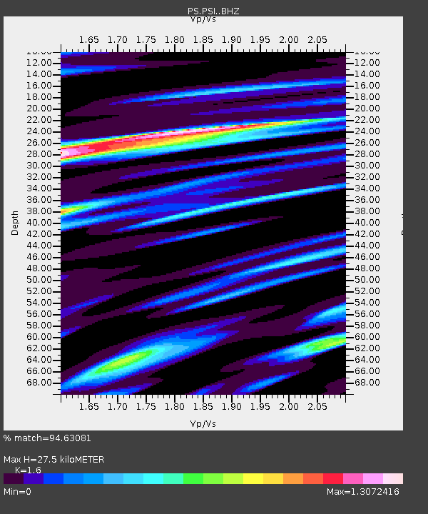
| Estimated Moho Depth: |
27.5 km |
| Estimated Crust Vp/Vs: |
1.60 |
| Assumed Crust Vp: |
6.468 km/s |
| Estimated Crust Vs: |
4.042 km/s |
| Estimated Crust Poisson's Ratio: |
0.18 |
|
| Radial Match: |
94.63081 % |
| Radial Bump: |
380 |
| Transverse Match: |
81.55932 % |
| Transverse Bump: |
400 |
| SOD ConfigId: |
13570011 |
| Insert Time: |
2019-04-29 20:58:02.902 +0000 |
| GWidth: |
2.5 |
| Max Bumps: |
400 |
| Tol: |
0.001 |
|
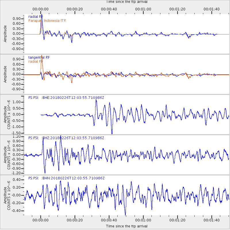
Signal To Noise
| Channel | StoN | STA | LTA |
| PS:PSI: :BHZ:20180226T12:03:55.710986Z | 12.523859 | 5.0161026E-7 | 4.005237E-8 |
| PS:PSI: :BHN:20180226T12:03:55.710986Z | 2.4709015 | 1.633497E-7 | 6.610936E-8 |
| PS:PSI: :BHE:20180226T12:03:55.710986Z | 9.360625 | 5.1707605E-7 | 5.5239475E-8 |
| Arrivals |
| Ps | 2.7 SECOND |
| PpPs | 10 SECOND |
| PsPs/PpSs | 13 SECOND |


