You are here: Home > Network List > TA - USArray Transportable Network (new EarthScope stations) Stations List
> Station 109C Camp Elliot, Mirimar, CA, USA > Earthquake Result Viewer
109C Camp Elliot, Mirimar, CA, USA - Earthquake Result Viewer
| Earthquake location: |
Caribbean Sea |
| Earthquake latitude/longitude: |
19.0/-81.4 |
| Earthquake time(UTC): |
2004/12/14 (349) 23:20:13 GMT |
| Earthquake Depth: |
10 km |
| Earthquake Magnitude: |
6.2 MB, 6.7 MS, 6.8 MW, 6.8 MW |
| Earthquake Catalog/Contributor: |
WHDF/NEIC |
|
| Network: |
TA USArray Transportable Network (new EarthScope stations) |
| Station: |
109C Camp Elliot, Mirimar, CA, USA |
| Lat/Lon: |
32.89 N/117.11 W |
| Elevation: |
150 m |
|
| Distance: |
34.8 deg |
| Az: |
300.642 deg |
| Baz: |
104.584 deg |
| Ray Param: |
0.07755819 |
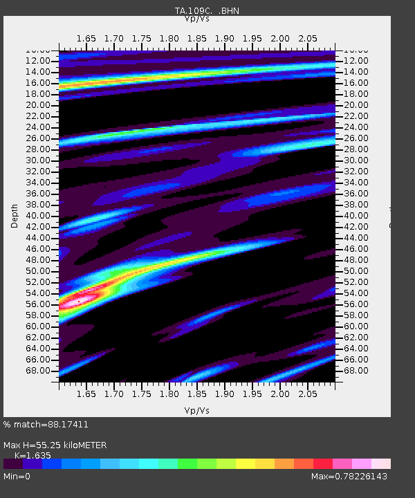
| Estimated Moho Depth: |
55.25 km |
| Estimated Crust Vp/Vs: |
1.63 |
| Assumed Crust Vp: |
6.264 km/s |
| Estimated Crust Vs: |
3.831 km/s |
| Estimated Crust Poisson's Ratio: |
0.20 |
|
| Radial Match: |
88.17411 % |
| Radial Bump: |
232 |
| Transverse Match: |
84.73334 % |
| Transverse Bump: |
322 |
| SOD ConfigId: |
2459 |
| Insert Time: |
2010-03-06 09:21:51.607 +0000 |
| GWidth: |
2.5 |
| Max Bumps: |
400 |
| Tol: |
0.001 |
|

Signal To Noise
| Channel | StoN | STA | LTA |
| TA:109C: :BHN:20041214T23:26:33.270004Z | 0.79611933 | 2.7471123E-7 | 3.450629E-7 |
| TA:109C: :BHE:20041214T23:26:33.270004Z | 6.829299 | 1.6252536E-6 | 2.379825E-7 |
| TA:109C: :BHZ:20041214T23:26:33.270004Z | 8.824323 | 2.6234554E-6 | 2.9729821E-7 |
| Arrivals |
| Ps | 6.1 SECOND |
| PpPs | 21 SECOND |
| PsPs/PpSs | 28 SECOND |


