You are here: Home > Network List > II - Global Seismograph Network (GSN - IRIS/IDA) Stations List
> Station WRAB Tennant Creek, NT, Australia > Earthquake Result Viewer
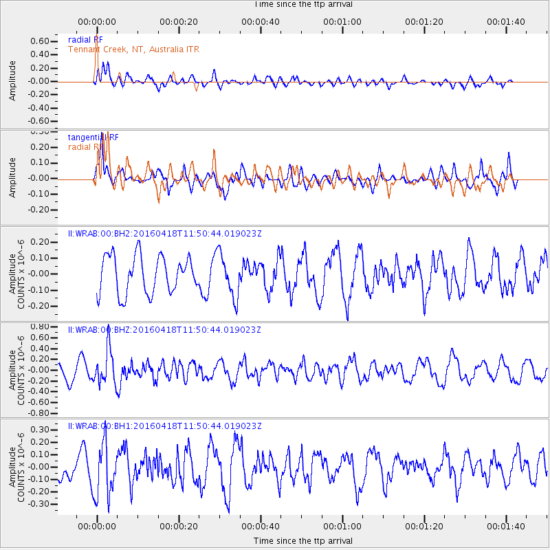
WRAB Tennant Creek, NT, Australia - Earthquake Result Viewer
*The percent match for this event was below the threshold and hence no stack was calculated.
| Earthquake location: |
Kyushu, Japan |
| Earthquake latitude/longitude: |
33.0/131.1 |
| Earthquake time(UTC): |
2016/04/18 (109) 11:41:59 GMT |
| Earthquake Depth: |
7.7 km |
| Earthquake Magnitude: |
5.5 MWW, 5.4 MWR, 5.5 MWC |
| Earthquake Catalog/Contributor: |
NEIC PDE/NEIC COMCAT |
|
| Network: |
II Global Seismograph Network (GSN - IRIS/IDA) |
| Station: |
WRAB Tennant Creek, NT, Australia |
| Lat/Lon: |
19.93 S/134.36 E |
| Elevation: |
366 m |
|
| Distance: |
52.7 deg |
| Az: |
176.15 deg |
| Baz: |
356.563 deg |
| Ray Param: |
$rayparam |
*The percent match for this event was below the threshold and hence was not used in the summary stack. |
|
| Radial Match: |
51.78492 % |
| Radial Bump: |
400 |
| Transverse Match: |
73.13846 % |
| Transverse Bump: |
400 |
| SOD ConfigId: |
1475611 |
| Insert Time: |
2016-05-06 12:26:06.170 +0000 |
| GWidth: |
2.5 |
| Max Bumps: |
400 |
| Tol: |
0.001 |
|
Signal To Noise
| Channel | StoN | STA | LTA |
| II:WRAB:00:BHZ:20160418T11:50:44.019023Z | 2.293492 | 3.298142E-7 | 1.438044E-7 |
| II:WRAB:00:BH1:20160418T11:50:44.019023Z | 2.139605 | 2.1514192E-7 | 1.0055217E-7 |
| II:WRAB:00:BH2:20160418T11:50:44.019023Z | 1.1903496 | 1.3721228E-7 | 1.1527057E-7 |
| Arrivals |
| Ps | |
| PpPs | |
| PsPs/PpSs | |


