You are here: Home > Network List > MM - Myanmar National Seismic Network Stations List
> Station TGI Taung Gyi, Myanmar > Earthquake Result Viewer
TGI Taung Gyi, Myanmar - Earthquake Result Viewer
| Earthquake location: |
Ceram Sea |
| Earthquake latitude/longitude: |
-2.8/126.7 |
| Earthquake time(UTC): |
2018/02/26 (057) 13:34:53 GMT |
| Earthquake Depth: |
6.3 km |
| Earthquake Magnitude: |
6.0 Mww |
| Earthquake Catalog/Contributor: |
NEIC PDE/us |
|
| Network: |
MM Myanmar National Seismic Network |
| Station: |
TGI Taung Gyi, Myanmar |
| Lat/Lon: |
20.77 N/97.03 E |
| Elevation: |
1458 m |
|
| Distance: |
37.3 deg |
| Az: |
310.173 deg |
| Baz: |
125.356 deg |
| Ray Param: |
0.07620757 |
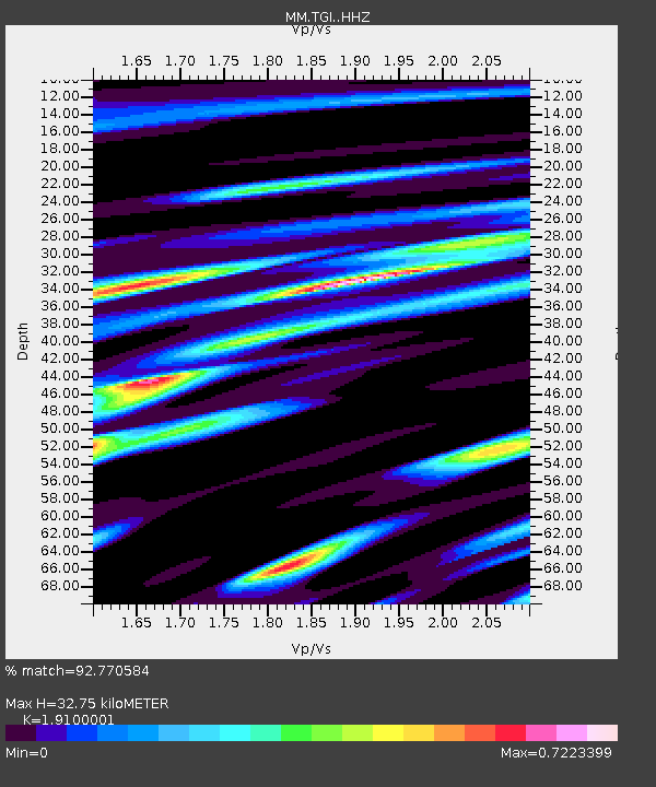
| Estimated Moho Depth: |
32.75 km |
| Estimated Crust Vp/Vs: |
1.91 |
| Assumed Crust Vp: |
6.316 km/s |
| Estimated Crust Vs: |
3.307 km/s |
| Estimated Crust Poisson's Ratio: |
0.31 |
|
| Radial Match: |
92.770584 % |
| Radial Bump: |
340 |
| Transverse Match: |
72.36092 % |
| Transverse Bump: |
400 |
| SOD ConfigId: |
13570011 |
| Insert Time: |
2019-04-29 21:02:18.339 +0000 |
| GWidth: |
2.5 |
| Max Bumps: |
400 |
| Tol: |
0.001 |
|

Signal To Noise
| Channel | StoN | STA | LTA |
| MM:TGI: :HHZ:20180226T13:41:35.379991Z | 3.438788 | 2.2114013E-7 | 6.430758E-8 |
| MM:TGI: :HHN:20180226T13:41:35.379991Z | 1.6466124 | 7.421777E-8 | 4.5073005E-8 |
| MM:TGI: :HHE:20180226T13:41:35.379991Z | 2.574962 | 1.2923157E-7 | 5.0187758E-8 |
| Arrivals |
| Ps | 5.0 SECOND |
| PpPs | 14 SECOND |
| PsPs/PpSs | 19 SECOND |


