You are here: Home > Network List > TA - USArray Transportable Network (new EarthScope stations) Stations List
> Station 109C Camp Elliot, Mirimar, CA, USA > Earthquake Result Viewer
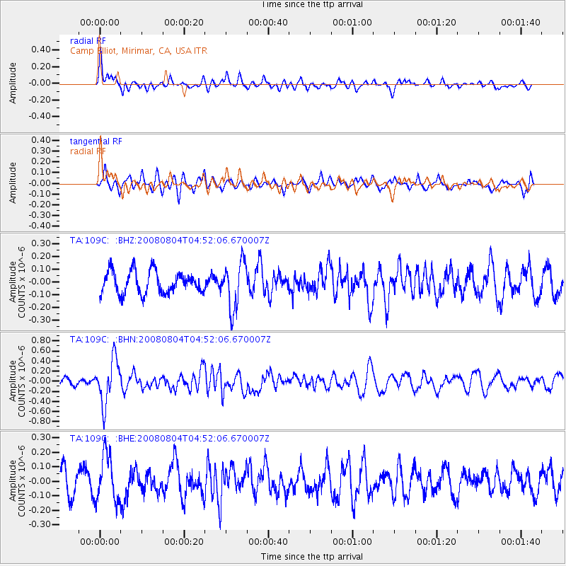
109C Camp Elliot, Mirimar, CA, USA - Earthquake Result Viewer
*The percent match for this event was below the threshold and hence no stack was calculated.
| Earthquake location: |
Kuril Islands |
| Earthquake latitude/longitude: |
49.9/156.4 |
| Earthquake time(UTC): |
2008/08/04 (217) 04:42:14 GMT |
| Earthquake Depth: |
77 km |
| Earthquake Magnitude: |
5.6 MB, 5.8 MW, 5.7 MW |
| Earthquake Catalog/Contributor: |
WHDF/NEIC |
|
| Network: |
TA USArray Transportable Network (new EarthScope stations) |
| Station: |
109C Camp Elliot, Mirimar, CA, USA |
| Lat/Lon: |
32.89 N/117.11 W |
| Elevation: |
150 m |
|
| Distance: |
63.6 deg |
| Az: |
69.689 deg |
| Baz: |
313.823 deg |
| Ray Param: |
$rayparam |
*The percent match for this event was below the threshold and hence was not used in the summary stack. |
|
| Radial Match: |
60.77667 % |
| Radial Bump: |
400 |
| Transverse Match: |
49.490482 % |
| Transverse Bump: |
400 |
| SOD ConfigId: |
2504 |
| Insert Time: |
2010-03-06 09:23:15.946 +0000 |
| GWidth: |
2.5 |
| Max Bumps: |
400 |
| Tol: |
0.001 |
|
Signal To Noise
| Channel | StoN | STA | LTA |
| TA:109C: :BHN:20080804T04:52:06.670007Z | 3.5893354 | 4.464731E-7 | 1.2438879E-7 |
| TA:109C: :BHE:20080804T04:52:06.670007Z | 1.6971116 | 1.6206444E-7 | 9.549427E-8 |
| TA:109C: :BHZ:20080804T04:52:06.670007Z | 2.1195436 | 1.8654275E-7 | 8.8010815E-8 |
| Arrivals |
| Ps | |
| PpPs | |
| PsPs/PpSs | |


