You are here: Home > Network List > TA - USArray Transportable Network (new EarthScope stations) Stations List
> Station G22K Bettles, AK, USA > Earthquake Result Viewer
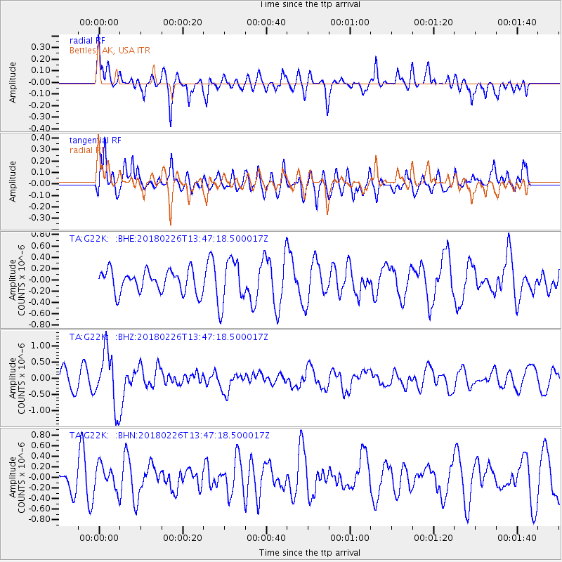
G22K Bettles, AK, USA - Earthquake Result Viewer
*The percent match for this event was below the threshold and hence no stack was calculated.
| Earthquake location: |
Ceram Sea |
| Earthquake latitude/longitude: |
-2.8/126.7 |
| Earthquake time(UTC): |
2018/02/26 (057) 13:34:53 GMT |
| Earthquake Depth: |
6.3 km |
| Earthquake Magnitude: |
6.0 Mww |
| Earthquake Catalog/Contributor: |
NEIC PDE/us |
|
| Network: |
TA USArray Transportable Network (new EarthScope stations) |
| Station: |
G22K Bettles, AK, USA |
| Lat/Lon: |
66.92 N/151.51 W |
| Elevation: |
205 m |
|
| Distance: |
89.3 deg |
| Az: |
22.968 deg |
| Baz: |
261.368 deg |
| Ray Param: |
$rayparam |
*The percent match for this event was below the threshold and hence was not used in the summary stack. |
|
| Radial Match: |
53.421352 % |
| Radial Bump: |
400 |
| Transverse Match: |
52.793808 % |
| Transverse Bump: |
400 |
| SOD ConfigId: |
13570011 |
| Insert Time: |
2019-04-29 21:03:06.680 +0000 |
| GWidth: |
2.5 |
| Max Bumps: |
400 |
| Tol: |
0.001 |
|
Signal To Noise
| Channel | StoN | STA | LTA |
| TA:G22K: :BHZ:20180226T13:47:18.500017Z | 3.0741289 | 8.7229523E-7 | 2.8375362E-7 |
| TA:G22K: :BHN:20180226T13:47:18.500017Z | 0.7099183 | 2.4040077E-7 | 3.386316E-7 |
| TA:G22K: :BHE:20180226T13:47:18.500017Z | 1.9470547 | 3.7780856E-7 | 1.9404106E-7 |
| Arrivals |
| Ps | |
| PpPs | |
| PsPs/PpSs | |


