You are here: Home > Network List > TA - USArray Transportable Network (new EarthScope stations) Stations List
> Station I30M Mount Dempster, Yukon, CAN > Earthquake Result Viewer
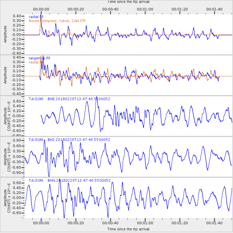
I30M Mount Dempster, Yukon, CAN - Earthquake Result Viewer
*The percent match for this event was below the threshold and hence no stack was calculated.
| Earthquake location: |
Ceram Sea |
| Earthquake latitude/longitude: |
-2.8/126.7 |
| Earthquake time(UTC): |
2018/02/26 (057) 13:34:53 GMT |
| Earthquake Depth: |
6.3 km |
| Earthquake Magnitude: |
6.0 Mww |
| Earthquake Catalog/Contributor: |
NEIC PDE/us |
|
| Network: |
TA USArray Transportable Network (new EarthScope stations) |
| Station: |
I30M Mount Dempster, Yukon, CAN |
| Lat/Lon: |
65.22 N/136.38 W |
| Elevation: |
1399 m |
|
| Distance: |
95.4 deg |
| Az: |
24.849 deg |
| Baz: |
275.12 deg |
| Ray Param: |
$rayparam |
*The percent match for this event was below the threshold and hence was not used in the summary stack. |
|
| Radial Match: |
60.918274 % |
| Radial Bump: |
400 |
| Transverse Match: |
70.818275 % |
| Transverse Bump: |
400 |
| SOD ConfigId: |
13570011 |
| Insert Time: |
2019-04-29 21:03:27.024 +0000 |
| GWidth: |
2.5 |
| Max Bumps: |
400 |
| Tol: |
0.001 |
|
Signal To Noise
| Channel | StoN | STA | LTA |
| TA:I30M: :BHZ:20180226T13:47:46.550005Z | 2.0520473 | 5.4476686E-7 | 2.6547482E-7 |
| TA:I30M: :BHN:20180226T13:47:46.550005Z | 1.3315699 | 2.9675863E-7 | 2.2286372E-7 |
| TA:I30M: :BHE:20180226T13:47:46.550005Z | 2.38875 | 4.580094E-7 | 1.91736E-7 |
| Arrivals |
| Ps | |
| PpPs | |
| PsPs/PpSs | |


