You are here: Home > Network List > TA - USArray Transportable Network (new EarthScope stations) Stations List
> Station J20K Nowitna River, AK, USA > Earthquake Result Viewer
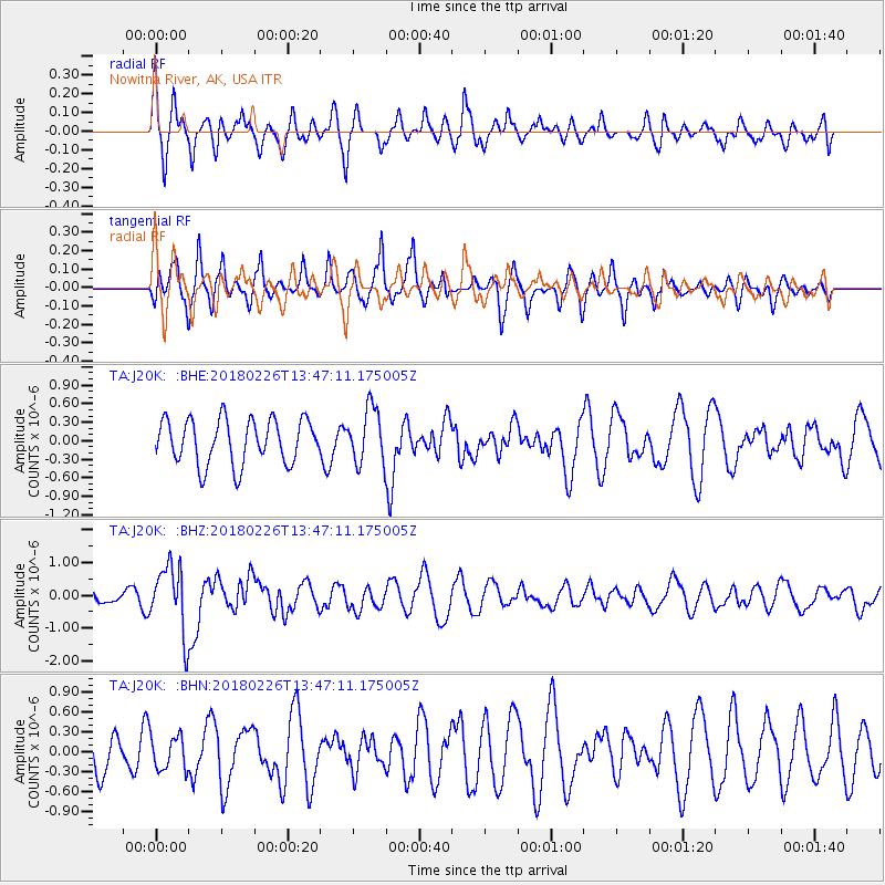
J20K Nowitna River, AK, USA - Earthquake Result Viewer
*The percent match for this event was below the threshold and hence no stack was calculated.
| Earthquake location: |
Ceram Sea |
| Earthquake latitude/longitude: |
-2.8/126.7 |
| Earthquake time(UTC): |
2018/02/26 (057) 13:34:53 GMT |
| Earthquake Depth: |
6.3 km |
| Earthquake Magnitude: |
6.0 Mww |
| Earthquake Catalog/Contributor: |
NEIC PDE/us |
|
| Network: |
TA USArray Transportable Network (new EarthScope stations) |
| Station: |
J20K Nowitna River, AK, USA |
| Lat/Lon: |
64.18 N/154.15 W |
| Elevation: |
314 m |
|
| Distance: |
87.8 deg |
| Az: |
25.497 deg |
| Baz: |
259.032 deg |
| Ray Param: |
$rayparam |
*The percent match for this event was below the threshold and hence was not used in the summary stack. |
|
| Radial Match: |
60.890488 % |
| Radial Bump: |
400 |
| Transverse Match: |
61.27262 % |
| Transverse Bump: |
400 |
| SOD ConfigId: |
13570011 |
| Insert Time: |
2019-04-29 21:03:29.964 +0000 |
| GWidth: |
2.5 |
| Max Bumps: |
400 |
| Tol: |
0.001 |
|
Signal To Noise
| Channel | StoN | STA | LTA |
| TA:J20K: :BHZ:20180226T13:47:11.175005Z | 4.2476873 | 1.0254035E-6 | 2.414028E-7 |
| TA:J20K: :BHN:20180226T13:47:11.175005Z | 0.79589105 | 2.5442057E-7 | 3.1966758E-7 |
| TA:J20K: :BHE:20180226T13:47:11.175005Z | 1.2619044 | 4.564919E-7 | 3.6174842E-7 |
| Arrivals |
| Ps | |
| PpPs | |
| PsPs/PpSs | |


