You are here: Home > Network List > TA - USArray Transportable Network (new EarthScope stations) Stations List
> Station L15K Ungalak Mountain, AK, USA > Earthquake Result Viewer
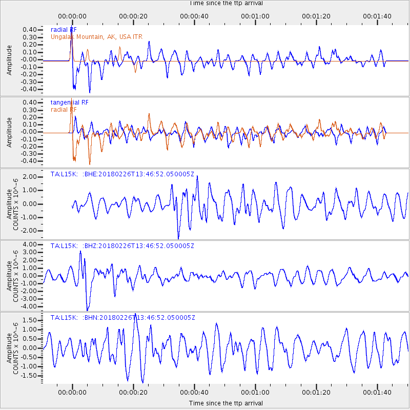
L15K Ungalak Mountain, AK, USA - Earthquake Result Viewer
*The percent match for this event was below the threshold and hence no stack was calculated.
| Earthquake location: |
Ceram Sea |
| Earthquake latitude/longitude: |
-2.8/126.7 |
| Earthquake time(UTC): |
2018/02/26 (057) 13:34:53 GMT |
| Earthquake Depth: |
6.3 km |
| Earthquake Magnitude: |
6.0 Mww |
| Earthquake Catalog/Contributor: |
NEIC PDE/us |
|
| Network: |
TA USArray Transportable Network (new EarthScope stations) |
| Station: |
L15K Ungalak Mountain, AK, USA |
| Lat/Lon: |
61.68 N/161.49 W |
| Elevation: |
219 m |
|
| Distance: |
83.9 deg |
| Az: |
27.107 deg |
| Baz: |
252.619 deg |
| Ray Param: |
$rayparam |
*The percent match for this event was below the threshold and hence was not used in the summary stack. |
|
| Radial Match: |
71.56977 % |
| Radial Bump: |
400 |
| Transverse Match: |
56.45985 % |
| Transverse Bump: |
400 |
| SOD ConfigId: |
13570011 |
| Insert Time: |
2019-04-29 21:03:36.755 +0000 |
| GWidth: |
2.5 |
| Max Bumps: |
400 |
| Tol: |
0.001 |
|
Signal To Noise
| Channel | StoN | STA | LTA |
| TA:L15K: :BHZ:20180226T13:46:52.050005Z | 3.2799308 | 1.6613816E-6 | 5.0652943E-7 |
| TA:L15K: :BHN:20180226T13:46:52.050005Z | 0.63686055 | 3.6111874E-7 | 5.6702953E-7 |
| TA:L15K: :BHE:20180226T13:46:52.050005Z | 2.0055716 | 8.362652E-7 | 4.1697098E-7 |
| Arrivals |
| Ps | |
| PpPs | |
| PsPs/PpSs | |


