You are here: Home > Network List > AU - Australian Seismological Centre Stations List
> Station XMIS Christmas Island Grants Well > Earthquake Result Viewer
XMIS Christmas Island Grants Well - Earthquake Result Viewer
| Earthquake location: |
New Guinea, Papua New Guinea |
| Earthquake latitude/longitude: |
-6.5/143.3 |
| Earthquake time(UTC): |
2018/02/26 (057) 15:17:57 GMT |
| Earthquake Depth: |
5.2 km |
| Earthquake Magnitude: |
6.3 Mww |
| Earthquake Catalog/Contributor: |
NEIC PDE/us |
|
| Network: |
AU Australian Seismological Centre |
| Station: |
XMIS Christmas Island Grants Well |
| Lat/Lon: |
10.48 S/105.65 E |
| Elevation: |
210 m |
|
| Distance: |
37.4 deg |
| Az: |
261.292 deg |
| Baz: |
87.015 deg |
| Ray Param: |
0.076173976 |
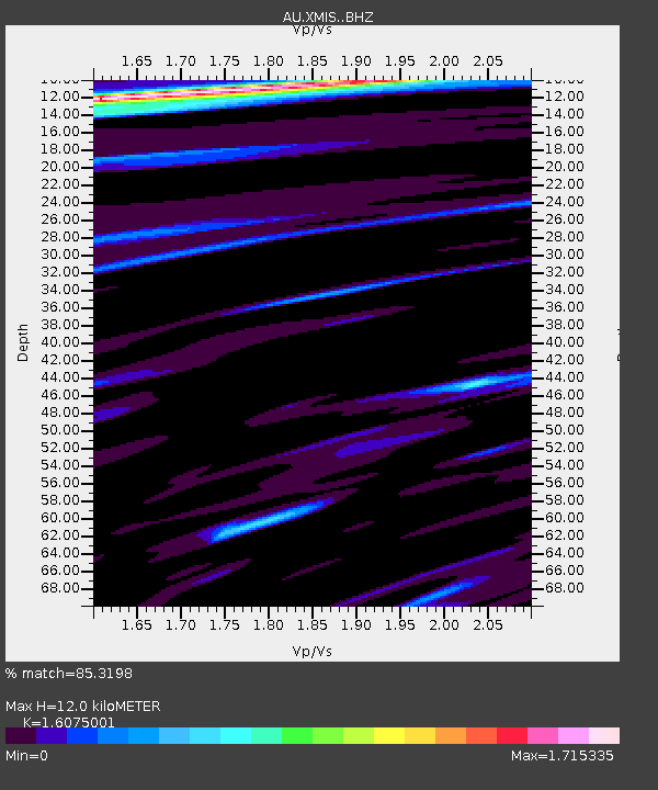
| Estimated Moho Depth: |
12.0 km |
| Estimated Crust Vp/Vs: |
1.61 |
| Assumed Crust Vp: |
4.157 km/s |
| Estimated Crust Vs: |
2.586 km/s |
| Estimated Crust Poisson's Ratio: |
0.18 |
|
| Radial Match: |
85.3198 % |
| Radial Bump: |
290 |
| Transverse Match: |
56.388763 % |
| Transverse Bump: |
400 |
| SOD ConfigId: |
13570011 |
| Insert Time: |
2019-04-29 21:05:21.305 +0000 |
| GWidth: |
2.5 |
| Max Bumps: |
400 |
| Tol: |
0.001 |
|

Signal To Noise
| Channel | StoN | STA | LTA |
| AU:XMIS: :BHZ:20180226T15:24:41.044003Z | 2.3742878 | 6.7753996E-7 | 2.8536556E-7 |
| AU:XMIS: :BHN:20180226T15:24:41.044003Z | 1.179025 | 3.7361164E-7 | 3.1688185E-7 |
| AU:XMIS: :BHE:20180226T15:24:41.044003Z | 2.4469347 | 5.319199E-7 | 2.1738215E-7 |
| Arrivals |
| Ps | 1.8 SECOND |
| PpPs | 7.3 SECOND |
| PsPs/PpSs | 9.1 SECOND |


