You are here: Home > Network List > PS - Pacific21 Stations List
> Station PSI Parapat, Indonesia > Earthquake Result Viewer
PSI Parapat, Indonesia - Earthquake Result Viewer
| Earthquake location: |
New Guinea, Papua New Guinea |
| Earthquake latitude/longitude: |
-6.5/143.3 |
| Earthquake time(UTC): |
2018/02/26 (057) 15:17:57 GMT |
| Earthquake Depth: |
5.2 km |
| Earthquake Magnitude: |
6.3 Mww |
| Earthquake Catalog/Contributor: |
NEIC PDE/us |
|
| Network: |
PS Pacific21 |
| Station: |
PSI Parapat, Indonesia |
| Lat/Lon: |
2.69 N/98.92 E |
| Elevation: |
987 m |
|
| Distance: |
45.2 deg |
| Az: |
280.291 deg |
| Baz: |
101.837 deg |
| Ray Param: |
0.07144987 |
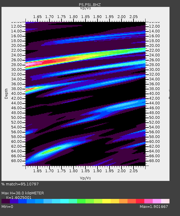
| Estimated Moho Depth: |
38.0 km |
| Estimated Crust Vp/Vs: |
1.60 |
| Assumed Crust Vp: |
6.468 km/s |
| Estimated Crust Vs: |
4.036 km/s |
| Estimated Crust Poisson's Ratio: |
0.18 |
|
| Radial Match: |
95.10797 % |
| Radial Bump: |
329 |
| Transverse Match: |
89.21812 % |
| Transverse Bump: |
400 |
| SOD ConfigId: |
13570011 |
| Insert Time: |
2019-04-29 21:06:45.924 +0000 |
| GWidth: |
2.5 |
| Max Bumps: |
400 |
| Tol: |
0.001 |
|
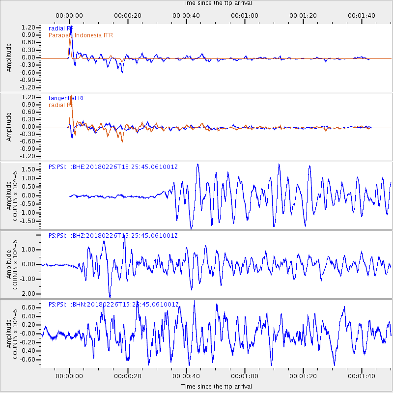
Signal To Noise
| Channel | StoN | STA | LTA |
| PS:PSI: :BHZ:20180226T15:25:45.061001Z | 3.8120577 | 1.5878734E-7 | 4.1653973E-8 |
| PS:PSI: :BHN:20180226T15:25:45.061001Z | 0.83637637 | 5.5072597E-8 | 6.584667E-8 |
| PS:PSI: :BHE:20180226T15:25:45.061001Z | 4.223039 | 1.8767926E-7 | 4.444175E-8 |
| Arrivals |
| Ps | 3.8 SECOND |
| PpPs | 14 SECOND |
| PsPs/PpSs | 18 SECOND |


