You are here: Home > Network List > GS - US Geological Survey Networks Stations List
> Station OK039 N2440 and E0440 Rds, Cleo Springs, OK, USA > Earthquake Result Viewer
OK039 N2440 and E0440 Rds, Cleo Springs, OK, USA - Earthquake Result Viewer
| Earthquake location: |
Near Coast Of Ecuador |
| Earthquake latitude/longitude: |
0.6/-80.3 |
| Earthquake time(UTC): |
2016/04/23 (114) 01:24:34 GMT |
| Earthquake Depth: |
10 km |
| Earthquake Magnitude: |
5.8 MWP |
| Earthquake Catalog/Contributor: |
NEIC PDE/NEIC COMCAT |
|
| Network: |
GS US Geological Survey Networks |
| Station: |
OK039 N2440 and E0440 Rds, Cleo Springs, OK, USA |
| Lat/Lon: |
36.38 N/98.65 W |
| Elevation: |
400 m |
|
| Distance: |
39.5 deg |
| Az: |
336.403 deg |
| Baz: |
150.263 deg |
| Ray Param: |
0.074963465 |
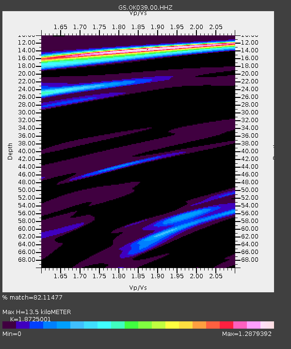
| Estimated Moho Depth: |
13.5 km |
| Estimated Crust Vp/Vs: |
1.87 |
| Assumed Crust Vp: |
6.426 km/s |
| Estimated Crust Vs: |
3.432 km/s |
| Estimated Crust Poisson's Ratio: |
0.30 |
|
| Radial Match: |
82.11477 % |
| Radial Bump: |
302 |
| Transverse Match: |
51.781742 % |
| Transverse Bump: |
365 |
| SOD ConfigId: |
1475611 |
| Insert Time: |
2016-05-07 01:27:21.059 +0000 |
| GWidth: |
2.5 |
| Max Bumps: |
400 |
| Tol: |
0.001 |
|

Signal To Noise
| Channel | StoN | STA | LTA |
| GS:OK039:00:HHZ:20160423T01:31:33.589996Z | 5.704371 | 1.1104188E-6 | 1.9466104E-7 |
| GS:OK039:00:HH1:20160423T01:31:33.589996Z | 2.9020412 | 6.450053E-7 | 2.2225919E-7 |
| GS:OK039:00:HH2:20160423T01:31:33.589996Z | 3.0224361 | 5.9087495E-7 | 1.9549626E-7 |
| Arrivals |
| Ps | 2.0 SECOND |
| PpPs | 5.6 SECOND |
| PsPs/PpSs | 7.6 SECOND |


