You are here: Home > Network List > TA - USArray Transportable Network (new EarthScope stations) Stations List
> Station A21K Barrow, AK, USA > Earthquake Result Viewer
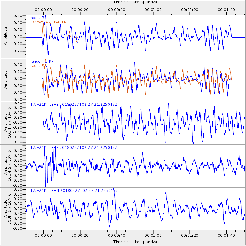
A21K Barrow, AK, USA - Earthquake Result Viewer
*The percent match for this event was below the threshold and hence no stack was calculated.
| Earthquake location: |
New Guinea, Papua New Guinea |
| Earthquake latitude/longitude: |
-6.6/143.2 |
| Earthquake time(UTC): |
2018/02/27 (058) 02:15:07 GMT |
| Earthquake Depth: |
10 km |
| Earthquake Magnitude: |
4.9 Mww |
| Earthquake Catalog/Contributor: |
NEIC PDE/us |
|
| Network: |
TA USArray Transportable Network (new EarthScope stations) |
| Station: |
A21K Barrow, AK, USA |
| Lat/Lon: |
71.32 N/156.62 W |
| Elevation: |
577 m |
|
| Distance: |
87.0 deg |
| Az: |
16.248 deg |
| Baz: |
239.635 deg |
| Ray Param: |
$rayparam |
*The percent match for this event was below the threshold and hence was not used in the summary stack. |
|
| Radial Match: |
46.11441 % |
| Radial Bump: |
400 |
| Transverse Match: |
67.650925 % |
| Transverse Bump: |
400 |
| SOD ConfigId: |
13570011 |
| Insert Time: |
2019-04-29 21:13:49.041 +0000 |
| GWidth: |
2.5 |
| Max Bumps: |
400 |
| Tol: |
0.001 |
|
Signal To Noise
| Channel | StoN | STA | LTA |
| TA:A21K: :BHZ:20180227T02:27:21.225015Z | 2.3441937 | 3.2641177E-7 | 1.3924266E-7 |
| TA:A21K: :BHN:20180227T02:27:21.225015Z | 0.5948308 | 1.6570756E-7 | 2.785793E-7 |
| TA:A21K: :BHE:20180227T02:27:21.225015Z | 1.3458891 | 3.706802E-7 | 2.754166E-7 |
| Arrivals |
| Ps | |
| PpPs | |
| PsPs/PpSs | |


