You are here: Home > Network List > TA - USArray Transportable Network (new EarthScope stations) Stations List
> Station 217A Green Valley, AZ, USA > Earthquake Result Viewer
217A Green Valley, AZ, USA - Earthquake Result Viewer
| Earthquake location: |
Easter Island Region |
| Earthquake latitude/longitude: |
-28.5/-112.8 |
| Earthquake time(UTC): |
2008/08/19 (232) 10:58:00 GMT |
| Earthquake Depth: |
9.0 km |
| Earthquake Magnitude: |
5.5 MB, 5.3 MS, 5.7 MW, 5.7 MW |
| Earthquake Catalog/Contributor: |
WHDF/NEIC |
|
| Network: |
TA USArray Transportable Network (new EarthScope stations) |
| Station: |
217A Green Valley, AZ, USA |
| Lat/Lon: |
31.77 N/110.82 W |
| Elevation: |
1412 m |
|
| Distance: |
60.0 deg |
| Az: |
1.992 deg |
| Baz: |
182.058 deg |
| Ray Param: |
0.061811008 |
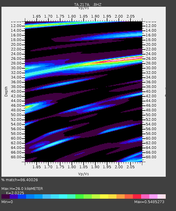
| Estimated Moho Depth: |
26.0 km |
| Estimated Crust Vp/Vs: |
2.02 |
| Assumed Crust Vp: |
6.264 km/s |
| Estimated Crust Vs: |
3.097 km/s |
| Estimated Crust Poisson's Ratio: |
0.34 |
|
| Radial Match: |
86.40026 % |
| Radial Bump: |
285 |
| Transverse Match: |
76.79767 % |
| Transverse Bump: |
380 |
| SOD ConfigId: |
2504 |
| Insert Time: |
2010-03-06 09:25:19.579 +0000 |
| GWidth: |
2.5 |
| Max Bumps: |
400 |
| Tol: |
0.001 |
|
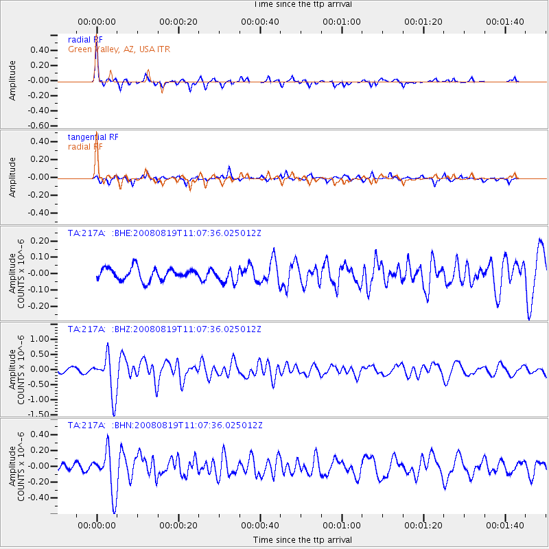
Signal To Noise
| Channel | StoN | STA | LTA |
| TA:217A: :BHZ:20080819T11:07:36.025012Z | 8.581369 | 6.7753217E-7 | 7.895385E-8 |
| TA:217A: :BHN:20080819T11:07:36.025012Z | 6.7487597 | 2.79447E-7 | 4.1407162E-8 |
| TA:217A: :BHE:20080819T11:07:36.025012Z | 1.2340276 | 4.4969582E-8 | 3.644131E-8 |
| Arrivals |
| Ps | 4.4 SECOND |
| PpPs | 12 SECOND |
| PsPs/PpSs | 16 SECOND |


