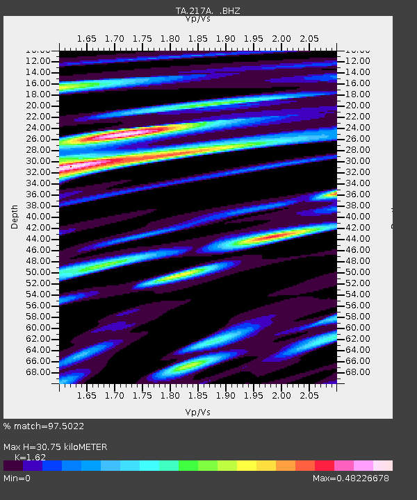
217A Green Valley, AZ, USA - Earthquake Result Viewer
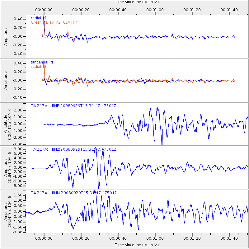
Earthquake location: Kermadec Islands, New Zealand
Earthquake latitude/longitude: -29.8/-177.7
Earthquake time(UTC): 2008/09/29 (273) 15:19:31 GMT
Earthquake Depth: 36 km
Earthquake Magnitude: 6.5 MB, 6.7 MS, 7.0 MW, 7.0 MW
Earthquake Catalog/Contributor: WHDF/NEIC
Network: TA USArray Transportable Network (new EarthScope stations)
Station: 217A Green Valley, AZ, USA
Lat/Lon: 31.77 N/110.82 W
Elevation: 1412 m
Distance: 88.2 deg
Az: 51.594 deg
Baz: 233.137 deg
Ray Param: 0.042748407
Estimated Moho Depth: 30.75 km
Estimated Crust Vp/Vs: 1.62
Assumed Crust Vp: 6.264 km/s
Estimated Crust Vs: 3.866 km/s
Estimated Crust Poisson's Ratio: 0.19
Radial Match: 97.5022 %
Radial Bump: 400
Transverse Match: 93.143776 %
Transverse Bump: 400
SOD ConfigId: 2560
Insert Time: 2010-03-06 09:25:23.480 +0000
GWidth: 2.5
Max Bumps: 400
Tol: 0.001

Signal To Noise

ChannelStoNSTALTA
TA:217A: :BHZ:20080929T15:31:47.47501Z7.8832565.322961E-76.7522365E-8
TA:217A: :BHN:20080929T15:31:47.47501Z2.33388662.123482E-79.09848E-8
TA:217A: :BHE:20080929T15:31:47.47501Z3.96737982.6260597E-76.6191284E-8
Arrivals
Ps3.1 SECOND
PpPs13 SECOND
PsPs/PpSs16 SECOND