You are here: Home > Network List > TA - USArray Transportable Network (new EarthScope stations) Stations List
> Station 217A Green Valley, AZ, USA > Earthquake Result Viewer
217A Green Valley, AZ, USA - Earthquake Result Viewer
| Earthquake location: |
Solomon Islands |
| Earthquake latitude/longitude: |
-10.9/162.1 |
| Earthquake time(UTC): |
2007/11/27 (331) 11:49:58 GMT |
| Earthquake Depth: |
16 km |
| Earthquake Magnitude: |
5.9 MB, 6.7 MS, 6.6 MW, 6.4 MW |
| Earthquake Catalog/Contributor: |
WHDF/NEIC |
|
| Network: |
TA USArray Transportable Network (new EarthScope stations) |
| Station: |
217A Green Valley, AZ, USA |
| Lat/Lon: |
31.77 N/110.82 W |
| Elevation: |
1412 m |
|
| Distance: |
93.2 deg |
| Az: |
58.417 deg |
| Baz: |
259.184 deg |
| Ray Param: |
0.041307304 |
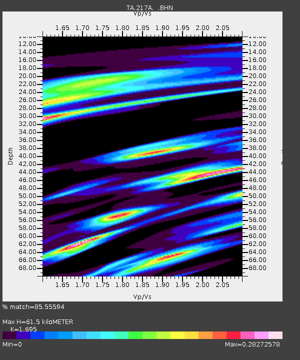
| Estimated Moho Depth: |
61.5 km |
| Estimated Crust Vp/Vs: |
1.70 |
| Assumed Crust Vp: |
6.264 km/s |
| Estimated Crust Vs: |
3.695 km/s |
| Estimated Crust Poisson's Ratio: |
0.23 |
|
| Radial Match: |
85.55594 % |
| Radial Bump: |
328 |
| Transverse Match: |
69.677414 % |
| Transverse Bump: |
400 |
| SOD ConfigId: |
2564 |
| Insert Time: |
2010-03-06 09:25:58.905 +0000 |
| GWidth: |
2.5 |
| Max Bumps: |
400 |
| Tol: |
0.001 |
|
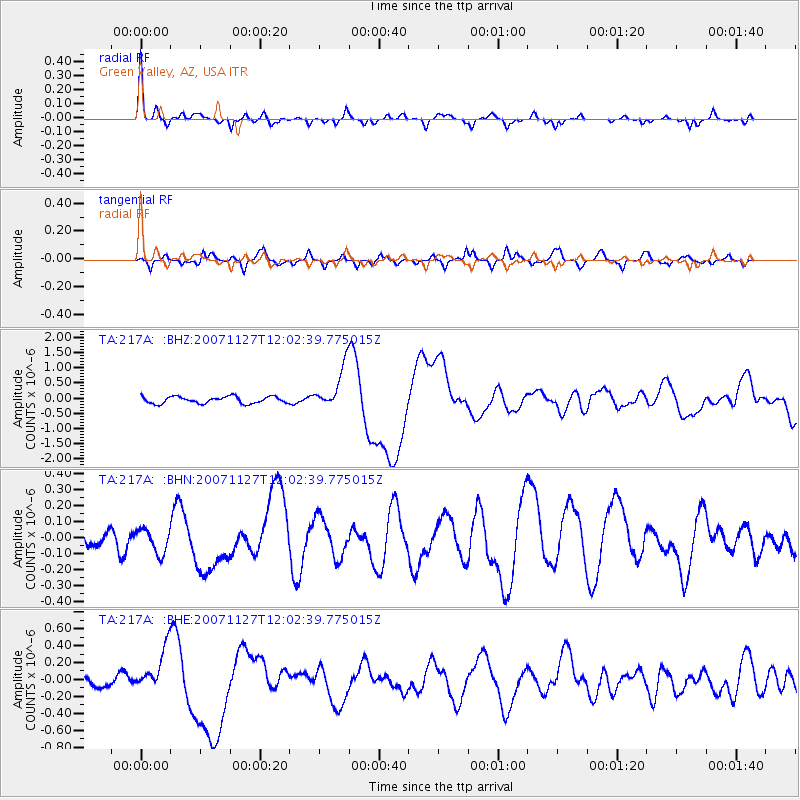
Signal To Noise
| Channel | StoN | STA | LTA |
| TA:217A: :BHN:20071127T12:02:39.775015Z | 1.4834077 | 8.176346E-8 | 5.5118665E-8 |
| TA:217A: :BHE:20071127T12:02:39.775015Z | 3.6182535 | 2.6772503E-7 | 7.3992894E-8 |
| TA:217A: :BHZ:20071127T12:02:39.775015Z | 6.3468566 | 7.04889E-7 | 1.1106112E-7 |
| Arrivals |
| Ps | 7.0 SECOND |
| PpPs | 26 SECOND |
| PsPs/PpSs | 33 SECOND |


