You are here: Home > Network List > TA - USArray Transportable Network (new EarthScope stations) Stations List
> Station 217A Green Valley, AZ, USA > Earthquake Result Viewer
217A Green Valley, AZ, USA - Earthquake Result Viewer
| Earthquake location: |
Kermadec Islands, New Zealand |
| Earthquake latitude/longitude: |
-30.0/-177.9 |
| Earthquake time(UTC): |
2007/11/20 (324) 15:28:28 GMT |
| Earthquake Depth: |
59 km |
| Earthquake Magnitude: |
6.0 MB, 5.9 MW, 5.8 MW |
| Earthquake Catalog/Contributor: |
WHDF/NEIC |
|
| Network: |
TA USArray Transportable Network (new EarthScope stations) |
| Station: |
217A Green Valley, AZ, USA |
| Lat/Lon: |
31.77 N/110.82 W |
| Elevation: |
1412 m |
|
| Distance: |
88.5 deg |
| Az: |
51.713 deg |
| Baz: |
233.053 deg |
| Ray Param: |
0.042440917 |
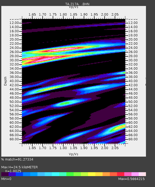
| Estimated Moho Depth: |
24.5 km |
| Estimated Crust Vp/Vs: |
1.80 |
| Assumed Crust Vp: |
6.264 km/s |
| Estimated Crust Vs: |
3.475 km/s |
| Estimated Crust Poisson's Ratio: |
0.28 |
|
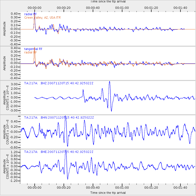
| Radial Match: |
91.27334 % |
| Radial Bump: |
302 |
| Transverse Match: |
82.63302 % |
| Transverse Bump: |
392 |
| SOD ConfigId: |
2564 |
| Insert Time: |
2010-03-06 09:26:01.559 +0000 |
| GWidth: |
2.5 |
| Max Bumps: |
400 |
| Tol: |
0.001 |
|
Signal To Noise
| Channel | StoN | STA | LTA |
| TA:217A: :BHN:20071120T15:40:42.925022Z | 2.0892503 | 1.3492816E-7 | 6.458209E-8 |
| TA:217A: :BHE:20071120T15:40:42.925022Z | 2.88635 | 1.9869788E-7 | 6.8840535E-8 |
| TA:217A: :BHZ:20071120T15:40:42.925022Z | 4.325732 | 6.3502796E-7 | 1.4680242E-7 |
| Arrivals |
| Ps | 3.2 SECOND |
| PpPs | 11 SECOND |
| PsPs/PpSs | 14 SECOND |


