You are here: Home > Network List > TA - USArray Transportable Network (new EarthScope stations) Stations List
> Station 217A Green Valley, AZ, USA > Earthquake Result Viewer
217A Green Valley, AZ, USA - Earthquake Result Viewer
| Earthquake location: |
Peru-Ecuador Border Region |
| Earthquake latitude/longitude: |
-2.3/-77.8 |
| Earthquake time(UTC): |
2007/11/16 (320) 03:13:00 GMT |
| Earthquake Depth: |
123 km |
| Earthquake Magnitude: |
6.3 MB, 6.8 MW, 6.7 MW |
| Earthquake Catalog/Contributor: |
WHDF/NEIC |
|
| Network: |
TA USArray Transportable Network (new EarthScope stations) |
| Station: |
217A Green Valley, AZ, USA |
| Lat/Lon: |
31.77 N/110.82 W |
| Elevation: |
1412 m |
|
| Distance: |
46.1 deg |
| Az: |
319.987 deg |
| Baz: |
131.035 deg |
| Ray Param: |
0.070407614 |
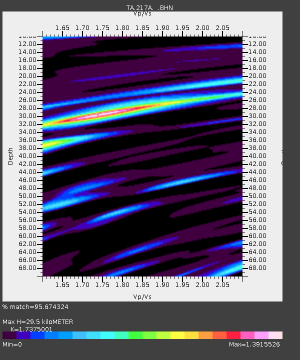
| Estimated Moho Depth: |
29.5 km |
| Estimated Crust Vp/Vs: |
1.74 |
| Assumed Crust Vp: |
6.264 km/s |
| Estimated Crust Vs: |
3.605 km/s |
| Estimated Crust Poisson's Ratio: |
0.25 |
|
| Radial Match: |
95.674324 % |
| Radial Bump: |
400 |
| Transverse Match: |
87.112724 % |
| Transverse Bump: |
400 |
| SOD ConfigId: |
2564 |
| Insert Time: |
2010-03-06 09:26:04.537 +0000 |
| GWidth: |
2.5 |
| Max Bumps: |
400 |
| Tol: |
0.001 |
|
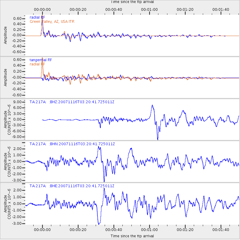
Signal To Noise
| Channel | StoN | STA | LTA |
| TA:217A: :BHN:20071116T03:20:41.725011Z | 4.5787344 | 5.072941E-7 | 1.10793515E-7 |
| TA:217A: :BHE:20071116T03:20:41.725011Z | 4.724757 | 5.1300276E-7 | 1.0857759E-7 |
| TA:217A: :BHZ:20071116T03:20:41.725011Z | 8.384168 | 1.3125134E-6 | 1.5654666E-7 |
| Arrivals |
| Ps | 3.7 SECOND |
| PpPs | 12 SECOND |
| PsPs/PpSs | 16 SECOND |


