You are here: Home > Network List > TA - USArray Transportable Network (new EarthScope stations) Stations List
> Station G16K Koyuk River, AK, USA > Earthquake Result Viewer
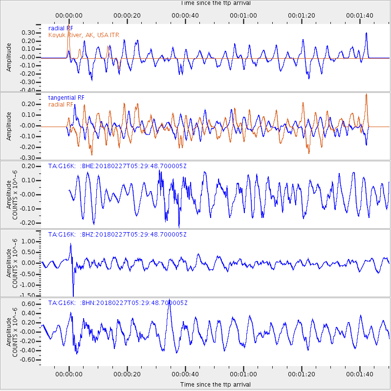
G16K Koyuk River, AK, USA - Earthquake Result Viewer
*The percent match for this event was below the threshold and hence no stack was calculated.
| Earthquake location: |
Vanuatu Islands |
| Earthquake latitude/longitude: |
-18.9/169.3 |
| Earthquake time(UTC): |
2018/02/27 (058) 05:17:58 GMT |
| Earthquake Depth: |
196 km |
| Earthquake Magnitude: |
5.5 Mww |
| Earthquake Catalog/Contributor: |
NEIC PDE/us |
|
| Network: |
TA USArray Transportable Network (new EarthScope stations) |
| Station: |
G16K Koyuk River, AK, USA |
| Lat/Lon: |
65.39 N/162.35 W |
| Elevation: |
169 m |
|
| Distance: |
86.7 deg |
| Az: |
11.488 deg |
| Baz: |
206.773 deg |
| Ray Param: |
$rayparam |
*The percent match for this event was below the threshold and hence was not used in the summary stack. |
|
| Radial Match: |
50.231106 % |
| Radial Bump: |
400 |
| Transverse Match: |
50.198524 % |
| Transverse Bump: |
400 |
| SOD ConfigId: |
13570011 |
| Insert Time: |
2019-04-29 21:18:43.554 +0000 |
| GWidth: |
2.5 |
| Max Bumps: |
400 |
| Tol: |
0.001 |
|
Signal To Noise
| Channel | StoN | STA | LTA |
| TA:G16K: :BHZ:20180227T05:29:48.700005Z | 2.3016512 | 4.570267E-7 | 1.9856469E-7 |
| TA:G16K: :BHN:20180227T05:29:48.700005Z | 1.5796518 | 2.6364822E-7 | 1.6690274E-7 |
| TA:G16K: :BHE:20180227T05:29:48.700005Z | 1.1883819 | 9.7583694E-8 | 8.211475E-8 |
| Arrivals |
| Ps | |
| PpPs | |
| PsPs/PpSs | |


