You are here: Home > Network List > TA - USArray Transportable Network (new EarthScope stations) Stations List
> Station I17K Unalakleet, AK, USA > Earthquake Result Viewer
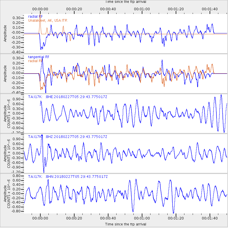
I17K Unalakleet, AK, USA - Earthquake Result Viewer
*The percent match for this event was below the threshold and hence no stack was calculated.
| Earthquake location: |
Vanuatu Islands |
| Earthquake latitude/longitude: |
-18.9/169.3 |
| Earthquake time(UTC): |
2018/02/27 (058) 05:17:58 GMT |
| Earthquake Depth: |
196 km |
| Earthquake Magnitude: |
5.5 Mww |
| Earthquake Catalog/Contributor: |
NEIC PDE/us |
|
| Network: |
TA USArray Transportable Network (new EarthScope stations) |
| Station: |
I17K Unalakleet, AK, USA |
| Lat/Lon: |
63.89 N/160.70 W |
| Elevation: |
105 m |
|
| Distance: |
85.7 deg |
| Az: |
12.825 deg |
| Baz: |
208.359 deg |
| Ray Param: |
$rayparam |
*The percent match for this event was below the threshold and hence was not used in the summary stack. |
|
| Radial Match: |
52.99088 % |
| Radial Bump: |
400 |
| Transverse Match: |
49.65168 % |
| Transverse Bump: |
349 |
| SOD ConfigId: |
13570011 |
| Insert Time: |
2019-04-29 21:18:51.288 +0000 |
| GWidth: |
2.5 |
| Max Bumps: |
400 |
| Tol: |
0.001 |
|
Signal To Noise
| Channel | StoN | STA | LTA |
| TA:I17K: :BHZ:20180227T05:29:43.775017Z | 2.601875 | 6.5105064E-7 | 2.5022362E-7 |
| TA:I17K: :BHN:20180227T05:29:43.775017Z | 1.3319665 | 3.4392838E-7 | 2.5821097E-7 |
| TA:I17K: :BHE:20180227T05:29:43.775017Z | 1.0873867 | 3.3491668E-7 | 3.0800146E-7 |
| Arrivals |
| Ps | |
| PpPs | |
| PsPs/PpSs | |


