You are here: Home > Network List > TA - USArray Transportable Network (new EarthScope stations) Stations List
> Station 217A Green Valley, AZ, USA > Earthquake Result Viewer
217A Green Valley, AZ, USA - Earthquake Result Viewer
| Earthquake location: |
Tonga Islands |
| Earthquake latitude/longitude: |
-17.5/-174.3 |
| Earthquake time(UTC): |
2007/08/26 (238) 12:37:31 GMT |
| Earthquake Depth: |
127 km |
| Earthquake Magnitude: |
5.9 MB, 6.1 MW |
| Earthquake Catalog/Contributor: |
WHDF/NEIC |
|
| Network: |
TA USArray Transportable Network (new EarthScope stations) |
| Station: |
217A Green Valley, AZ, USA |
| Lat/Lon: |
31.77 N/110.82 W |
| Elevation: |
1412 m |
|
| Distance: |
78.1 deg |
| Az: |
51.178 deg |
| Baz: |
240.826 deg |
| Ray Param: |
0.04957065 |
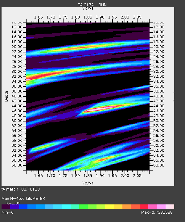
| Estimated Moho Depth: |
45.0 km |
| Estimated Crust Vp/Vs: |
1.89 |
| Assumed Crust Vp: |
6.264 km/s |
| Estimated Crust Vs: |
3.314 km/s |
| Estimated Crust Poisson's Ratio: |
0.31 |
|
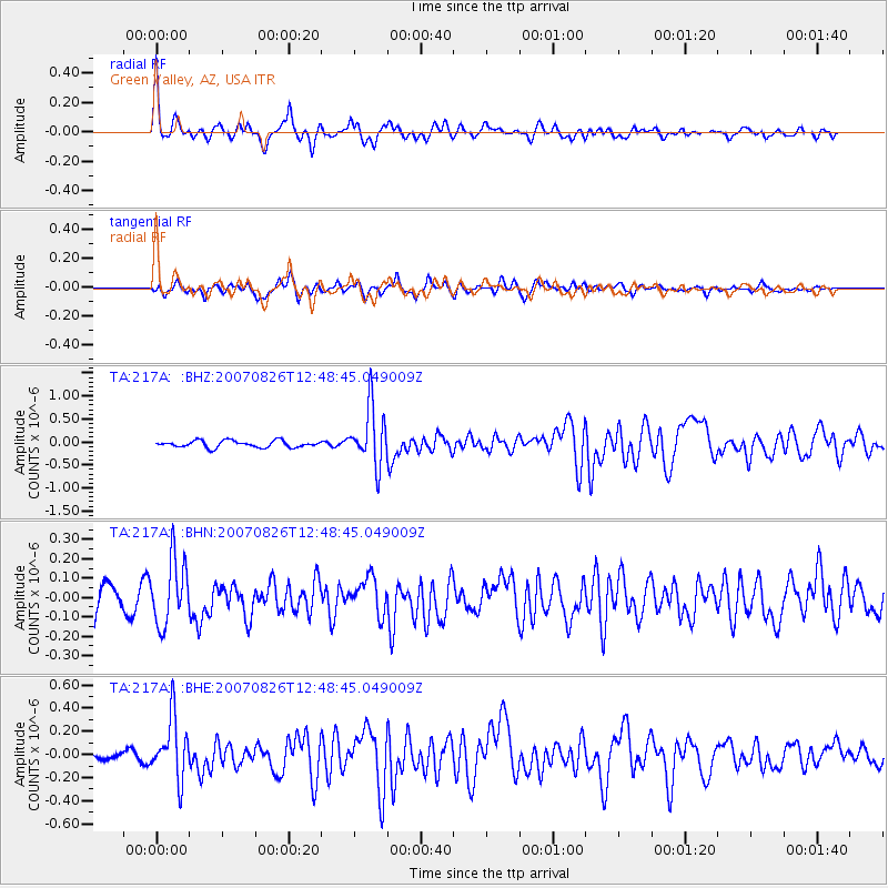
| Radial Match: |
83.70113 % |
| Radial Bump: |
359 |
| Transverse Match: |
56.34026 % |
| Transverse Bump: |
400 |
| SOD ConfigId: |
2564 |
| Insert Time: |
2010-03-06 09:26:37.396 +0000 |
| GWidth: |
2.5 |
| Max Bumps: |
400 |
| Tol: |
0.001 |
|
Signal To Noise
| Channel | StoN | STA | LTA |
| TA:217A: :BHN:20070826T12:48:45.049009Z | 2.3114214 | 1.6769775E-7 | 7.2551785E-8 |
| TA:217A: :BHE:20070826T12:48:45.049009Z | 6.144657 | 2.610773E-7 | 4.2488505E-8 |
| TA:217A: :BHZ:20070826T12:48:45.049009Z | 8.662948 | 6.302709E-7 | 7.275479E-8 |
| Arrivals |
| Ps | 6.6 SECOND |
| PpPs | 20 SECOND |
| PsPs/PpSs | 27 SECOND |


