You are here: Home > Network List > TA - USArray Transportable Network (new EarthScope stations) Stations List
> Station 217A Green Valley, AZ, USA > Earthquake Result Viewer
217A Green Valley, AZ, USA - Earthquake Result Viewer

| Earthquake location: |
Vanuatu Islands |
| Earthquake latitude/longitude: |
-15.4/168.6 |
| Earthquake time(UTC): |
2007/07/15 (196) 09:27:34 GMT |
| Earthquake Depth: |
8.0 km |
| Earthquake Magnitude: |
6.0 MB, 5.8 MS, 6.1 MW, 6.0 MW |
| Earthquake Catalog/Contributor: |
WHDF/NEIC |
|
| Network: |
TA USArray Transportable Network (new EarthScope stations) |
| Station: |
217A Green Valley, AZ, USA |
| Lat/Lon: |
31.77 N/110.82 W |
| Elevation: |
1412 m |
|
| Distance: |
90.2 deg |
| Az: |
57.165 deg |
| Baz: |
252.109 deg |
| Ray Param: |
0.04168952 |
| Estimated Moho Depth: |
26.0 km |
| Estimated Crust Vp/Vs: |
1.70 |
| Assumed Crust Vp: |
6.264 km/s |
| Estimated Crust Vs: |
3.684 km/s |
| Estimated Crust Poisson's Ratio: |
0.24 |
|
| Radial Match: |
93.39506 % |
| Radial Bump: |
393 |
| Transverse Match: |
87.22285 % |
| Transverse Bump: |
400 |
| SOD ConfigId: |
2564 |
| Insert Time: |
2010-03-06 09:27:02.670 +0000 |
| GWidth: |
2.5 |
| Max Bumps: |
400 |
| Tol: |
0.001 |
|
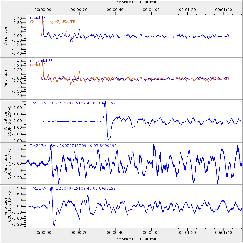
Signal To Noise
| Channel | StoN | STA | LTA |
| TA:217A: :BHN:20070715T09:40:03.849019Z | 2.425857 | 8.782895E-8 | 3.620533E-8 |
| TA:217A: :BHE:20070715T09:40:03.849019Z | 12.145234 | 3.7154038E-7 | 3.0591455E-8 |
| TA:217A: :BHZ:20070715T09:40:03.849019Z | 37.22844 | 1.1272422E-6 | 3.027906E-8 |
| Arrivals |
| Ps | 3.0 SECOND |
| PpPs | 11 SECOND |
| PsPs/PpSs | 14 SECOND |


