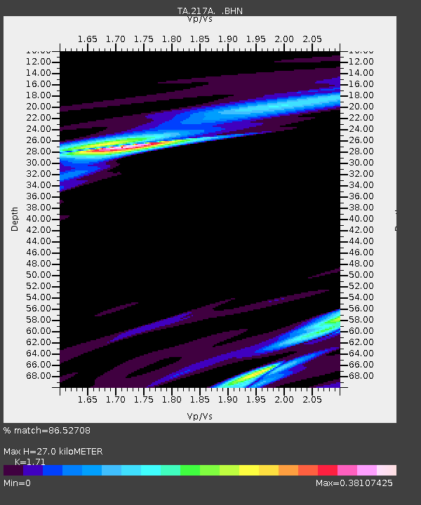
217A Green Valley, AZ, USA - Earthquake Result Viewer
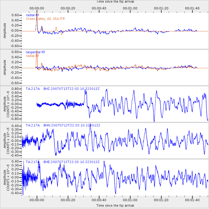
Earthquake location: Andreanof Islands, Aleutian Is.
Earthquake latitude/longitude: 51.8/-176.3
Earthquake time(UTC): 2007/07/13 (194) 21:54:43 GMT
Earthquake Depth: 35 km
Earthquake Magnitude: 5.7 MB, 5.6 MS, 6.0 MW, 5.9 MW
Earthquake Catalog/Contributor: WHDF/NEIC
Network: TA USArray Transportable Network (new EarthScope stations)
Station: 217A Green Valley, AZ, USA
Lat/Lon: 31.77 N/110.82 W
Elevation: 1412 m
Distance: 50.9 deg
Az: 86.473 deg
Baz: 313.356 deg
Ray Param: 0.06767221
Estimated Moho Depth: 27.0 km
Estimated Crust Vp/Vs: 1.71
Assumed Crust Vp: 6.264 km/s
Estimated Crust Vs: 3.663 km/s
Estimated Crust Poisson's Ratio: 0.24
Radial Match: 86.52708 %
Radial Bump: 400
Transverse Match: 59.729237 %
Transverse Bump: 400
SOD ConfigId: 2564
Insert Time: 2010-03-06 09:27:04.816 +0000
GWidth: 2.5
Max Bumps: 400
Tol: 0.001

Signal To Noise

ChannelStoNSTALTA
TA:217A: :BHN:20070713T22:03:10.323013Z1.04043221.124353E-71.08065954E-7
TA:217A: :BHE:20070713T22:03:10.323013Z1.96813381.8497606E-79.398551E-8
TA:217A: :BHZ:20070713T22:03:10.323013Z6.30320934.1315153E-76.554622E-8
Arrivals
Ps3.2 SECOND
PpPs11 SECOND
PsPs/PpSs14 SECOND