You are here: Home > Network List > TA - USArray Transportable Network (new EarthScope stations) Stations List
> Station B18K Kokolik River, AK, USA > Earthquake Result Viewer
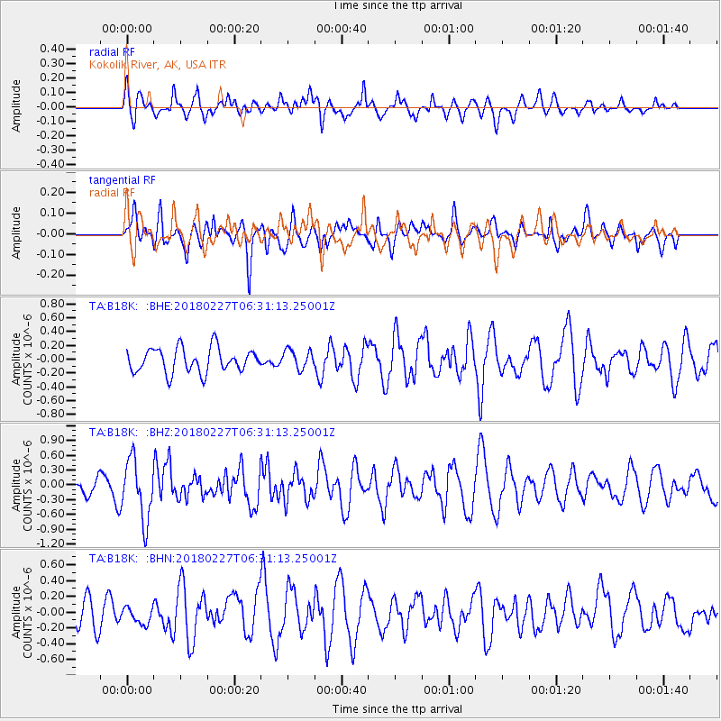
B18K Kokolik River, AK, USA - Earthquake Result Viewer
*The percent match for this event was below the threshold and hence no stack was calculated.
| Earthquake location: |
New Guinea, Papua New Guinea |
| Earthquake latitude/longitude: |
-6.4/143.0 |
| Earthquake time(UTC): |
2018/02/27 (058) 06:19:12 GMT |
| Earthquake Depth: |
10 km |
| Earthquake Magnitude: |
5.6 Mww |
| Earthquake Catalog/Contributor: |
NEIC PDE/us |
|
| Network: |
TA USArray Transportable Network (new EarthScope stations) |
| Station: |
B18K Kokolik River, AK, USA |
| Lat/Lon: |
69.36 N/161.80 W |
| Elevation: |
222 m |
|
| Distance: |
84.4 deg |
| Az: |
16.997 deg |
| Baz: |
235.033 deg |
| Ray Param: |
$rayparam |
*The percent match for this event was below the threshold and hence was not used in the summary stack. |
|
| Radial Match: |
60.16486 % |
| Radial Bump: |
400 |
| Transverse Match: |
48.882874 % |
| Transverse Bump: |
400 |
| SOD ConfigId: |
13570011 |
| Insert Time: |
2019-04-29 21:22:27.969 +0000 |
| GWidth: |
2.5 |
| Max Bumps: |
400 |
| Tol: |
0.001 |
|
Signal To Noise
| Channel | StoN | STA | LTA |
| TA:B18K: :BHZ:20180227T06:31:13.25001Z | 2.2141583 | 6.086288E-7 | 2.7488042E-7 |
| TA:B18K: :BHN:20180227T06:31:13.25001Z | 0.49954295 | 1.00316576E-7 | 2.0081673E-7 |
| TA:B18K: :BHE:20180227T06:31:13.25001Z | 0.7889842 | 1.3877987E-7 | 1.758969E-7 |
| Arrivals |
| Ps | |
| PpPs | |
| PsPs/PpSs | |


