You are here: Home > Network List > TA - USArray Transportable Network (new EarthScope stations) Stations List
> Station 217A Green Valley, AZ, USA > Earthquake Result Viewer
217A Green Valley, AZ, USA - Earthquake Result Viewer
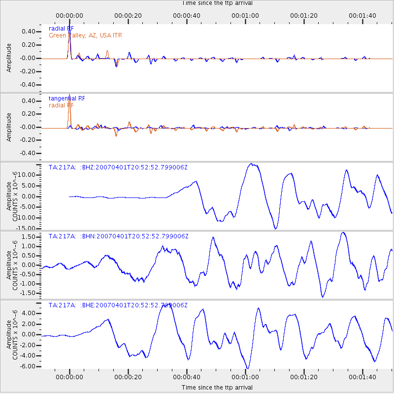
| Earthquake location: |
Solomon Islands |
| Earthquake latitude/longitude: |
-8.5/157.0 |
| Earthquake time(UTC): |
2007/04/01 (091) 20:39:56 GMT |
| Earthquake Depth: |
10 km |
| Earthquake Magnitude: |
6.8 MB, 7.9 MS, 8.1 MW, 7.7 ME |
| Earthquake Catalog/Contributor: |
WHDF/NEIC |
|
| Network: |
TA USArray Transportable Network (new EarthScope stations) |
| Station: |
217A Green Valley, AZ, USA |
| Lat/Lon: |
31.77 N/110.82 W |
| Elevation: |
1412 m |
|
| Distance: |
96.2 deg |
| Az: |
58.884 deg |
| Baz: |
263.93 deg |
| Ray Param: |
0.040579226 |
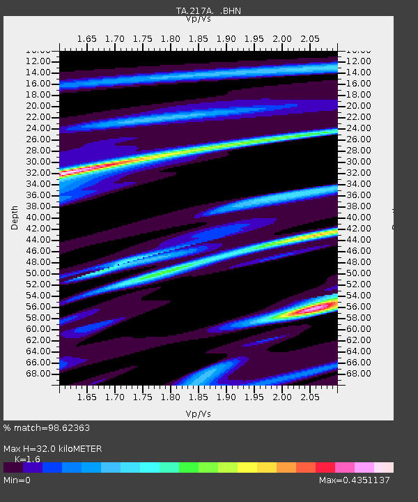
| Estimated Moho Depth: |
32.0 km |
| Estimated Crust Vp/Vs: |
1.60 |
| Assumed Crust Vp: |
6.264 km/s |
| Estimated Crust Vs: |
3.915 km/s |
| Estimated Crust Poisson's Ratio: |
0.18 |
|
| Radial Match: |
98.62363 % |
| Radial Bump: |
174 |
| Transverse Match: |
91.44189 % |
| Transverse Bump: |
349 |
| SOD ConfigId: |
2564 |
| Insert Time: |
2010-03-06 09:27:16.339 +0000 |
| GWidth: |
2.5 |
| Max Bumps: |
400 |
| Tol: |
0.001 |
|
Signal To Noise
| Channel | StoN | STA | LTA |
| TA:217A: :BHN:20070401T20:52:52.799006Z | 1.009322 | 1.12260224E-7 | 1.1122339E-7 |
| TA:217A: :BHE:20070401T20:52:52.799006Z | 2.2492445 | 2.0450949E-7 | 9.0923635E-8 |
| TA:217A: :BHZ:20070401T20:52:52.799006Z | 1.7106593 | 4.1866946E-7 | 2.4474159E-7 |
| Arrivals |
| Ps | 3.1 SECOND |
| PpPs | 13 SECOND |
| PsPs/PpSs | 16 SECOND |


