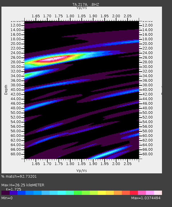
217A Green Valley, AZ, USA - Earthquake Result Viewer
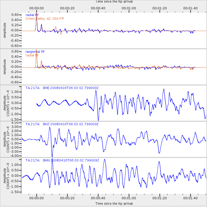
Earthquake location: Andreanof Islands, Aleutian Is.
Earthquake latitude/longitude: 51.9/-179.2
Earthquake time(UTC): 2008/04/16 (107) 05:54:19 GMT
Earthquake Depth: 13 km
Earthquake Magnitude: 6.1 MB, 6.5 MS, 6.6 MW, 6.6 MW
Earthquake Catalog/Contributor: WHDF/NEIC
Network: TA USArray Transportable Network (new EarthScope stations)
Station: 217A Green Valley, AZ, USA
Lat/Lon: 31.77 N/110.82 W
Elevation: 1412 m
Distance: 52.7 deg
Az: 84.353 deg
Baz: 313.589 deg
Ray Param: 0.066584714
Estimated Moho Depth: 26.25 km
Estimated Crust Vp/Vs: 1.73
Assumed Crust Vp: 6.264 km/s
Estimated Crust Vs: 3.631 km/s
Estimated Crust Poisson's Ratio: 0.25
Radial Match: 92.73201 %
Radial Bump: 397
Transverse Match: 62.21315 %
Transverse Bump: 400
SOD ConfigId: 2504
Insert Time: 2010-03-06 09:27:27.711 +0000
GWidth: 2.5
Max Bumps: 400
Tol: 0.001

Signal To Noise

ChannelStoNSTALTA
TA:217A: :BHZ:20080416T06:03:02.799009Z2.1550444.0850006E-71.8955532E-7
TA:217A: :BHN:20080416T06:03:02.799009Z2.0829822.7844717E-71.3367718E-7
TA:217A: :BHE:20080416T06:03:02.799009Z1.36464752.0868195E-71.5292004E-7
Arrivals
Ps3.2 SECOND
PpPs11 SECOND
PsPs/PpSs14 SECOND